• Home
  • About Geogypsy
    • Herstory
    • Parks where I’ve worked
  • Places I’ve been
    • United States
      • Arizona
        • Antelope Slot Canyon
        • Casa Grande Ruins National Monument
        • Colossal Cave Mountain Park
        • Flagstaff
        • Glen Canyon National Recreation Area
        • Grand Canyon National Park
          • Grand Canyon National Park North Rim
          • Grand Canyon National Park South Rim
          • Toroweap
        • Havasu Canyon
        • Horseshoe Bend
        • Jerome
        • Kaibab National Forest
        • Lee’s Ferry
        • Meteor Crater
        • Navajo Bridge
        • Oak Creek Canyon
        • Painted Desert
        • Pipe Springs National Monument
        • Prescott
        • Quartzsite
        • Saguaro National Park
        • Sedona
        • Sunset Crater Volcano National Monument
        • Vermilion Cliffs
        • Walnut Canyon National Monument
        • Wupatki National Monument
        • Yarnell
      • California
        • Anzaberrego
        • Bakersfield
        • Death Valley National Park
        • Joshua Tree National Park
        • Redwoods NP
        • Salton Sea
        • Yucca Valley
      • Colorado
        • Mesa Verde National Park
      • Florida
      • Illinois
        • IL River
        • Morton Arboretum
        • Starved Rock State Park
      • Michigan
      • Nevada
      • New Mexico
      • Oregon
        • Crater Lake NP
        • Mt Hood
        • Oregon Caves National Monument
      • Texas
        • Alpine Texas
        • Padre Island
        • Port Isabel
        • Rio Grande Valley
      • Utah
        • Brian’s Head
        • Bryce Canyon National Park
        • Buckskin Gulch
        • Cedar Breaks National Monument
        • Cedar City
        • Coral Pink Sand Dunes State Park
        • Dixie National Forest
        • Grand Staircase Escalante National Monument
        • Johnson Canyon
        • Kanab
    • World Travels
      • Germany
      • Mexico
      • South Africa
  • Tours
  • Photography
  • Work with Me
    • Sponsors
  • Contact
Geogypsy
Menu
  • Home
  • About Geogypsy
    • Herstory
    • Parks where I’ve worked
  • Places I’ve been
    • United States
      • Arizona
        • Antelope Slot Canyon
        • Casa Grande Ruins National Monument
        • Colossal Cave Mountain Park
        • Flagstaff
        • Glen Canyon National Recreation Area
        • Grand Canyon National Park
          • Grand Canyon National Park North Rim
          • Grand Canyon National Park South Rim
          • Toroweap
        • Havasu Canyon
        • Horseshoe Bend
        • Jerome
        • Kaibab National Forest
        • Lee’s Ferry
        • Meteor Crater
        • Navajo Bridge
        • Oak Creek Canyon
        • Painted Desert
        • Pipe Springs National Monument
        • Prescott
        • Quartzsite
        • Saguaro National Park
        • Sedona
        • Sunset Crater Volcano National Monument
        • Vermilion Cliffs
        • Walnut Canyon National Monument
        • Wupatki National Monument
        • Yarnell
      • California
        • Anzaberrego
        • Bakersfield
        • Death Valley National Park
        • Joshua Tree National Park
        • Redwoods NP
        • Salton Sea
        • Yucca Valley
      • Colorado
        • Mesa Verde National Park
      • Florida
      • Illinois
        • IL River
        • Morton Arboretum
        • Starved Rock State Park
      • Michigan
      • Nevada
      • New Mexico
      • Oregon
        • Crater Lake NP
        • Mt Hood
        • Oregon Caves National Monument
      • Texas
        • Alpine Texas
        • Padre Island
        • Port Isabel
        • Rio Grande Valley
      • Utah
        • Brian’s Head
        • Bryce Canyon National Park
        • Buckskin Gulch
        • Cedar Breaks National Monument
        • Cedar City
        • Coral Pink Sand Dunes State Park
        • Dixie National Forest
        • Grand Staircase Escalante National Monument
        • Johnson Canyon
        • Kanab
    • World Travels
      • Germany
      • Mexico
      • South Africa
  • Tours
  • Photography
  • Work with Me
    • Sponsors
  • Contact

Category: RV life

25 August 2023

How I find free boondocking

I get asked all the time how I find free boondocking.  It’s a process of planning.

view SE rds mts anticrepuscular rays reverse sunset cloudsIf you’ve followed me for any length of time you know I find free boondocking in some amazing places in the middle of absolutely nowhere (MOAN) with often expansive and spectacular views.  I love all landscapes from desert, forest, beach, and mountains.  Yet have discovered over my 46 years of RV traveling I really like distant views with something(s) in the foreground.  So that’s what I look for.  I don’t care for crowded RV Parks or campgrounds.  Part of my experience includes listening to the sounds of the world around me.

Public lands mapThe USA has over 800 million acres of public land* and a lot of it is accessible and open to free boondocking.  What is boondocking you ask?  There is debate, but my personal definition means I’m not plugged in to any electricity ( I have adequate solar), water, or sewer—known as full-hookups—because there isn’t any.  It’s free, and usually found in the middle of nowhere, rural, remote, and frequently off gravel roads.  Dry camping, also without full-hookups, free or paid can happen in many places: rest areas—know the state’s laws—if self-contained and not a tent, some parking lots with permission, along streets if small enough to stealth and look like you belong there, campgrounds on public lands, edge of a RV park.  Always look for signs and ask, be prepared for “the knock” while your sleeping then told to move.  When in doubt, ask the source not your Aunt’s brother’s dog.  If you’re looking at public land, there’s a government agency managing it, like BLM, FS, FWS, NPS, plus state and local governments.  (Bureau of Land Management, Forest Service, Fish & Wildlife Service, National Park Service)

How I find free boondocking 

I like to plan but am good with it not coming together because I include so many options.  In fact my travel plans are usually way too lofty and long without a chance of including it all.  But that’s OK, just means I can come back.

Know before you go, plan like a Park Ranger, be prepared for change, and be flexible

DeLorme Nevada Atlas & GazetteerFor example, when I left Utah after visiting friends I headed for Nevada.  Having never been in central or northern Nevada before the first thing I did was check my map.  Yes, an actual paper map, Nevada DeLemore Atlas and Gazetteer.  I like to look at a bigger picture than my phone for possible roads and places to see.  Plus there’s not always cell signal everywhere and when there is I take a screenshot of the information I need.  Because I don’t typically stay in RV Parks or designated campgrounds I look for public lands, starting with my paper map I find the managing agency and look at their website for the area.  Mostly that’s so I know their rules and if there’s any closures.

Next I check  weather apps, National Weather Service, The Weather Channel, and Weather Bug.  I like my temperatures about 70-80/40-50° with no huge storms coming in my direction.  I also check for fire and smoke, never pleasant to camp near.

iOverlander mapThen I go to camping apps like Campendium, FreeRoam, or mostly iOverlander to see what other people recommend in my chosen area.  There are many other apps out there but a lot of them you have to pay for, and I’m a cheapskate.

St Geo UT to Cathedral Gorge SP NVI often pin and save likely places on Google Maps app and usually take a screen shot of the directions.  Finally, I sometimes go to Google Earth to really zoom in on a location to see landscape and maybe even road conditions.  That doesn’t always work because it’s not in real time.  If the road looks doubtful, don’t go there.  Even with a high-clearance, non-4×4 pickup truck hauling a huge slide-in camper I often don’t go if roads look too rough.  I will drive 3-5 miles of decent to washboard gravel roads, very slowly.  When arriving at my chosen site that tends to be a side-road, I park and walk in to make sure it’s doable because I need overhead clearance and don’t like to backup too far.  I usually have a backup plan for at least one other free boondocking site.

truckcamper sunset clouds
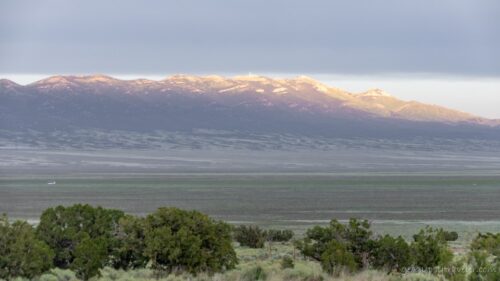
BTW, this free boondocking location will be revealed in the next blog post.

There’s beauty everywhere I go, and for me that doesn’t include cities, big towns, and interstate like highways.  I’m a nature lover and find peace within the natural world.

*About 640 million acres managed by the federal government, about 28% from a total of 2.27 billion acres.  95% by BLM, FWS, NPS and FS.  Another almost 200 million acres of public land not managed by the federal government, instead by state and local governments.  The majority of public lands are located in Alaska and Western states.

Push my buttons!

  • Click to share on Facebook (Opens in new window) Facebook
  • Click to share on X (Opens in new window) X
  • Click to share on LinkedIn (Opens in new window) LinkedIn

Like this:

Like Loading...
boondocking, RV life planning, road trip 18 Comments
26 July 2023

No bad views of Grand Canyon

Wotons Throne & Cape Royal Desert View SR GRCA NP AZ

view S Cape Royal NR GRCA NP AZMultiple views of Grand Canyon, Wotan’s Throne from South Rim and North Rim

When I was a Park Ranger visitors frequently asked which side is better, there’s no bad views of Grand Canyon, so visit both sides.  And that’s what I did.

trees canyon CO R clouds Navajo Pt SR GRCA NP AZ

light in canyon Navajo Pt SR GRCA NP AZOn this summer journey, I planned to enjoy views of Grand Canyon from both sides, starting with the South Rim.  So after my wonderful loop drive from Sunset Crater to Wupatki national monuments I continued north on SR89 to Cameron and entered the park from the east side, so much less crowded than the main Village area.

orange Globe Mallow flowers canyon CO R clouds Navajo Pt SR GRCA NP AZ

Desert View Tower Navajo Pt SR GRCA NP AZI stopped at Navajo Point and under cloudy skies enjoyed the views of Grand Canyon including a distant look at the Desert View Watch Tower.

truckcamper Kaibab NF AZThen I continued to my forest camp only one mile of rough and rutted dirt road to boondock for the night with a gentle rain.  Not overcrowded, this Kaibab National Forest location is along the way to the Grandview Fire Tower, where I camped last summer.

west view Moran Pt SR GRCA NP AZ

temple pk Moran Pt SR GRCA NP AZThe next day I met a Ranger friend at Moran Point and we spent the day catching up, reminiscing, and enjoying views of Grand Canyon.  I am always amazed that the average park visitor doesn’t spend more than two minutes at an overlook.

 late light Ponderosa Pine needles FR310 Kaibab NF AZ

Ponderosa Pine flower FR310 Kaibab NF AZ

pine pollen puddle reflection FR310 Kaibaba NF AZPine pollen on puddle

pine pollen on windshield S Kaibab NF AZPollen on truck

It rained intermittently over the next several days so I was glad to have a great signal and worked on the next video about Arivaca Creek and the Cruz Ranch and a blog post about my visit to Bisbee during early June.  Yes, I’m that far behind.  The rain helped clear the air of Pine pollen.

CO R Desert View SR GRCA NP AZ

Desert View Watchtower SR GRCA NP AZAfter five nights in this forest location it was time to hit the road for some new views of Grand Canyon.  First stop at Desert View Watch Tower, the furthest east overlook with some of my favorite South Rim views of Grand Canyon.

blue Larkspur flowers FR310 Kaibab NF AZMoth on orange Globe Mallow flower Desert View SR GRCA NP AZ

                           Larkspur                                                                                Globe Mallow

I parked in the oversized vehicle lot and walked due west to the rim following a social trail towards the tower with lots of flowers along the way.

Desert View Watchtower SR GRCA NP AZ

GRCA stickers & hat pinThe only reason I went inside the tower was to add another sticker and hat pin to my collections.

SR89 N AZ

Echo Cliffs Navajo Rez SR89 N AZOnce back to SR89 I headed north across the amazing Navajo Reservation desert landscape.

Echo & Vermilion Cliffs SR89A W AZ

menu Cliff Dwellers SR89A Hatch AZStopped for lunch at Cliff Dwellers then climbed up onto the Kaibab Plateau and much cooler temperatures at 7,000 feet.

cookies Jacob Lake Inn AZOf course I had to get desert at Jacob Lake Inn.

truckcamper Jacob Lake AZThen opted to camp nearby.

cows person Crane Lk snow Kaibab NF AZIn the morning I drove south across the Kaibab National Forest surprised at how full the lakes were in the meadows.  Guess I should have expected that because of the record breaking snow fall.

light on Aspen Kaibab NF AZStopped at the entrance station and said hello to a known Ranger then continued to the end of the road.

Grand Lodge verandah NR GRCA NP AZParking wasn’t a problem because the Lodge wasn’t open yet for food service or overnight accommodations.  All that snow followed by melt took out a huge section of both the water pipe and North Kaibab trail so they were under water restrictions.

view from lodge NR GRCA NP AZNo Rangers in the visitor center as it’s now all sales space for the history association.

Mt Hayden Pt Imperial NR GRCA NP AZ

Saddle Mt Marble Canyon Vermilion Cliffs clouds Pt Imperial NR GRCA NP AZEnough of that, I wanted more views of Grand Canyon.  So I drove the scenic road with the first stop at Point Imperial.  I actually had the overlook entirely to myself for a measurable amount of time.

Greenland Lake NR GRCA NP AZ


light on Aspen leaves NR GRCA NP AZ

Made another stop at Greenland Lake, the fullest I’ve ever seen, and I’ve seen it bone dry.  “Lakes” on the Kaibab are actually sinkholes in the limestone, not huge but good water sources for wildlife.

Wotons Throne Wedding Site NR GRCA NP AZ

yellow Desert Sunflower flowers in rock hole Cape Royal NR GRCA NP AZThen on to the end of the road to Cape Royal for my favorite views of Grand Canyon.

sunset Cape Royal NR GRCA NP AZ

sunset thru pines Cape Royal NR GRCA NP AZ

sunset Cape Royal NR GRCA NP AZ

Wotons Throne sunset clouds Cape Royal NR GRCA NP AZEspecially sunset.

Deer Lake Kaibab NF AZDeer Lake

view E Marble Plateau Vermilion Cliffs Navajo Mt Kaibab NF AZView east Vermilion & Echo Cliffs with Navajo Mt beyond

I could have stayed for days stopping at every overlook for many hours enjoying a variety of views of Grand Canyon.  However, I had other places to go and people to see.  So I headed back north with just a couple stops along the way.  Including Jacob Lake Inn once again for a dozen cookies to take as treats for the friends I’d visit in Kanab, Utah.

Push my buttons!

  • Click to share on Facebook (Opens in new window) Facebook
  • Click to share on X (Opens in new window) X
  • Click to share on LinkedIn (Opens in new window) LinkedIn

Like this:

Like Loading...
Arizona, Grand Canyon National Park, North Rim, Places I've been, RV life, South Rim, United States national parks, Park Ranger, RV living, summer 2023 20 Comments
28 June 2023

On the road for summer

Yes, I am far behind blogging, and also posting videos. It’s already a busy summer.  In fact I’m trying to catch them up to at least the same amount of time behind.  I last posted about the amazing pillars of rocks in Chiricahua National Monument visited in April, and that video can be found here.

late light boulders Indian Bread Rocks RA BLM Bowie AZIndian Bread Rocks Recreation Area

The next place I stayed at for two weeks, so lots of photos coming with that story.

trees rainbow storm clouds Skull Valley AZYes, I went home for several weeks to regroup, make plans, and not be on the road for Memorial Day weekend.  Maybe I’m crazy to travel during summer.

First of June I left for summer travels.  First I visited several friends and don’t have much to share from those stops, but do have many wonderful memories.

grass SF Pks rain clouds FR545 Wupatki NM AZSan Francisco Peaks from Wupatki National Monument

I returned to a few familiar places with different views.

Wotons Throne & Cape Royal Desert View SR GRCA NP AZWotons Throne from South Rim

view S Cape Royal NR GRCA NP AZWotons Throne from North Rim

Then I went to the South and North rims of Grand Canyon and that story and pics will be coming, eventually.

view S JP cliffs mt clouds SR320 Pioche NVBLM camp view near Pioche Nevada

Finally got to Utah and visited several more friends before starting to feel the heat of summer and heading into Nevada to several new to me places.

old log cabin Dutch John Well US93 NVDutch John Well

And I’m enthralled with Nevada landscapes.

view N red Paintbrush flowers scrub trees Egan Range sunset clouds White Pine County Rd 3 NVAs a friend said MOAN, for the Middle of ABSOLUTELY Nowhere, along America’s Loneliest Highway.  It’s gorgeous!  And the high elevation keeps me summer cool.

Jakey Valley and Egan Range

And now I find myself waiting for another holiday weekend to pass, avoiding possible rain, and staying in temperatures below 90°.

Kanab UTPainted on a street in Kanab Utah

Where next?  Stay tuned, and I will catch up eventually.  I might even make it to Oregon this summer.

Push my buttons!

  • Click to share on Facebook (Opens in new window) Facebook
  • Click to share on X (Opens in new window) X
  • Click to share on LinkedIn (Opens in new window) LinkedIn

Like this:

Like Loading...
Arizona, Nevada, Places I've been, RV life, United States, Utah boondocking, friendocking, RV living, summer 17 Comments
← Older posts
Newer posts →

Hi, I’m Gaelyn, the Geogypsy

I retired after 29 summer seasons as a Park Ranger, traveling solo for 40+ years. My passions include travel, connecting to nature, photography, and sharing stories.

I started exploring US National Parks in 1977 and 20 years later became a seasonal Park Ranger.  I’ve lived full-time in a RV for 30 years working summers and playing winters.  I’m still trying to figure out what I want to be when I grow old, other than grow up.

Let’s share our stories.  Here’s more of mine…

My wheeleastate

I am currently…

…boondocking somewhere in southern Arizona.  In the area, give a shout.

Geogypsytraveler on YouTube

Follow my journey on YouTube. Just click the pic. Hope you’ll like, share, and subscribe.

Click image for 7 minute documentary (Password “geogypsy” lowercase)

Making the Gypsy documentary is a story of its own.  Click below for the rest of the story.

Living nomadically & connecting to nature documentary

Subscribe to Blog via Email

Enter your email address to subscribe to this blog and receive notifications of new posts by email.

Photos available for sale include prints, greeting cards, coffee mugs, tote bags, phone cases and more

Reflected Wave 24X16 metal print under $100

Custom Coffee Mugs

Many items to choose from including prints

The Last Blast 24 x 16″ metal print under $100

Need a signal boost? When I boondock on public lands sometimes signal is weak or intermittent and a booster helps. Click the pic to visit WeBoost.

Connecting to nature and the rest of the world too.

Please contact me for photo purchases not seen at GLOlmsted Photography

Order fulfillment is by Fine Art America. If you’re not happy with your purchase, for any reason, simply return it within 30 days, and you’ll receive a full refund of the purchase price.

Why read Geogypsy?

The gypsy life spring-summer 1998 - "You were a real pioneer. RV'ing before it was cool." ...Yogi

How do you process photos? - “Your photographs create an Emotional feeling in the viewer...that they become One with You.” …Cindy

Life’s transitions between travel and work play - "I know you love your job as much as you love travel -- it shines through all your posts." ...Sallie

Lions at Kruger National Park - “Wonderful post, thank you. I was hooked start to finish!” … Peter B

11 lessons looking back 2013 - “A great post -- made me think, made me smile, made me want to cry." ...Sallie

Wildlife video Kruger National Park - “Gorgeous, this makes me want to go straight to South Africa now.” … Ayngelina

Living nomadically & connecting to nature documentary - “What an experience you had and gave to the "crew." Sometimes I think you don't realize how unique and inspiring you are.” …Alan

Search

Popular Posts

1. Prioritize the well-being of nature over photography. 2. Educate yourself about the places you photograph. 3. Reflect on the possible impact of your actions. 4. Use discretion if sharing locations. 5. Know and follow rules and regulations. 6. Always follow Leave No Trace principles and strive to leave places better than you found them. 7. Actively promote and educate others about these principles

Categories

Archives

Sites I follow, read & recommend

  • A Full-time Life
  • A Yankee in Belgrade
  • Bob's Eyes
  • Box Canyon Blog
  • Camels and Chocolate
  • Dawns bloggy blog
  • In the Direction of Our Dreams
  • Jane in her infinite wisdom
  • Janie and Steve, Utah Trails
  • Kathie's Birds
  • Las Adventuras
  • Memorable Meanders
  • Oh, The Places They Go
  • On the Road Abode
  • Port Elizabeth Daily Photo
  • Stillhowlyntravels
  • Take to the Highway
  • Technomadia
  • the good luck Duck
  • Travel with the Bayfield Bunch
  • Wandering Earl
  • Wheeling It
  • Yogi's Den

Caught in a Slot 9×12 canvas print under $50

If you don’t like what’s going on in your government, contact your Congress

Directory of Senators

Directory of Representatives

Lijit

© Copyright 2008-2024. Geogypsytraveler.com
%d