
Even at lower elevation, temperatures dropping caused me more than one desert dilemma beyond being cold.
 My first desert dilemma was the seemingly abandoned and broken trailer near where I decided to camp causing me to wonder if I should even park there. I have camped in this area before. Two days later, after dark, some noisy truck towed it away. Sadly, they left trash behind, lots of it. I had considered doing a video of the trailer and mess. This, is one of the reasons public land management agencies use to close dispersed camping. If we can’t take care of the land, we’ll loose the right to visit.
 Halloween caused no desert dilemma without trick or treaters, not even on the trail-cam. Good thing, as I had no candy. When I grew up, Halloween was mostly a community holiday, dressing up and joining local friends to beg from the neighbors. Community is different now with many not even knowing their neighbors. I don’t socialize with neighbors, if I can even see them often just due to distance. Maybe your community is closer knit. Much of my community is visited online, here on the blog, social media, and now YouTube who recently opened a Community option to my young channel. I’m still trying to figure out how it works, and think many others are also. My interpretation of the Geogypsy Community is a tribe of like minded people who enjoy communicating. I posted a video about it here, and put up a short poll here that got one response in 11 days. I guess my community isn’t very big, yet.
 The Congress camp community has nearby human-dug waterholes for livestock so I figured that would bring in more than just cattle. I set the trail-cam pointed at said waterhole but other than cows, seems only quick moving birds or bats triggered it after dark. That felt like a desert dilemma as water usually draws wildlife.

 Sunsets frequently cause the desert dilemma of which way to look because it’s 360°, especially at the end of an otherwise gray cloudy day.
 And I do love clouds, but gray days mean less solar charging and that causes a desert dilemma because I live off-grid and rely on my camper battery to operate lights, start the fridge, and charge phone and laptop. A drive 20 minutes each way to Wickenburg helped charge the “house” battery. Yet after every stop in town I noticed the solar controller flashing “b01”, an error warning for very low or dead battery. My cheap battery tester indicated the one-year-old battery was good. Lights worked, fridge lit, and phone charged. Now what? I checked fuses and wiggled wires which solved the error, briefly. Loose wires are always a nightmare. Being I had an appointment for an oil change in two days at B&B Automotive just five miles from my Congress camp I figured to let them solve this desert dilemma.

 And enjoyed another night of gorgeous sunset.
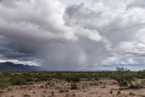
 Except the next day was raining with awesome cloud shows and most of my desert dilemma was which way to look and point the camera.
 While it rained I set the phone on tripod in the camper door with my drape over it to keep the rain out and Sierra in. I took some awesome time-lapse and shared a video here.

 In between rain drops I was in and out of the camper all day taking photos.

 Sunset was no slouch either.
 Friday morning I got packed and ready to roll for that oil change. The shop called to say I could come in before my 11:30am appointment. Oh boy, stop at the dump on the way and get rid of a week’s worth of garbage for $1. But the truck wouldn’t start, as in dead batteries. No problem, I put the handy jumper on it and waited 30 minutes. Truck still wouldn’t start. Now that’s a desert dilemma. Called the shop and they eventually sent a mechanic out but his larger jumper still wouldn’t start the truck. Only five miles from the shop but I’d have to get a tow. My first thought was the old fashioned way of finding a BIG truck and pulling my unit with a chain, but now days that means the driveshaft would have to be dropped. It was just a thought.
 Wild horses
Being the shop is closed on weekends I figured the tow could wait until Monday morning. I’d rather stay in my pretty camp than a parking lot over the weekend.
 Started by calling a couple tow companies in the closest town of Wickenburg and several didn’t have a truck big enough to tow my truck with the camper on it. No way the camper would be coming off. It’s a pain to come off and on, plus I couldn’t abandon it on public land with Sierra inside. I finally called Good Sam Road Care Assistance. I’ve paid for this service almost 20 years and thankfully only used it about seven times. One tow pays for all. But they are a pain in ass to deal with. Last call years ago the lady I spoke to in Georgia didn’t even know what state the Grand Canyon is in. Duh! This lady in Illinois at least found me on maps but didn’t know what a “slide-in cabover truckcamper” is or what is boondocking/dispersed camping/off grid. I recommended she ask for better training from Good Sam and tried to educate her. I also gave her the name and number of the nearest tow company with a truck big enough that could find me. But no, Good Sam has their system, a rather screwed up system. She tried several tow companies out of the Phoenix area (two hours away) but when I followed up they couldn’t tow my truck with the camper on. But finally found one and I scheduled the tow for Monday morning, when I would get a text conformation. I have heard many horror stories from RVers about both Good Sam and AAA. They will get to you, eventually.
 Painted Lady well camouflaged
 With that done I had the whole weekend to just enjoy the sunny desert.

 Except, the solar controller still indicated a dead house battery. Could there be a correlation? While driving the truck should help charge the house battery, but it shouldn’t deplete that battery. Oh well, everything was working so I falsely assumed it was the controller and not the battery.
 I spent most of the weekend reading and outdoors soaking up the sun watching my world. Plus I ate a little extra ice cream just in case the fridge stopped lighting.

 And I watched for the rise of the almost full moon over the Weaver Mountains.
 By Sunday night I had no interior lights, dead laptop battery, and low phone battery. But I’d be OK because my tow would come Monday morning. Except for yet another desert dilemma. Morning text from Good Sam listed a tow company that couldn’t tow my truck. I lost my patience and vented on Face Book tagging Good Sam and within 30 minutes they responded and we were private messengering with much better service than the phone call. After several more tries they finally enlisted a company from the Phoenix area and it would be two more hours before they’d get to me. I talked the driver into my rather remote location, but only about one mile off SR89 pavement. Poor guy was way out of his element.
 Sadly, my truck couldn’t be pulled onto the tipped tow truck bed without tearing off the back of the camper. I had thought that would be a problem. But before just putting the front wheels up only a bit instead the driver hooked up his mega jumper, and the truck started. Yea! He followed me the five miles to the repair shop where I had to buy two new truck batteries. And OUCH, have they gotten expensive! They also charged my house battery up to 85%. No time for an oil change and a reschedule would be two weeks out. Not happening.
 With the fridge back on I went back to the same camp to watch the moon for a couple more nights. And maybe the lunar eclipse.
 But that night I woke up feeling nauseous and lost dinner into a waste basket. Trust me, you don’t want to pray to a RV toilet. And maybe not eat ice cream right on top of lemon chicken. So no lunar eclipse and Tuesday was a down day. Except for a cloudy full moon rise.

 Rained over night but not enough to flood, which can be a desert dilemma. Woke to an amazing sunrise followed by heavy clouds and more rain that was suppose to clear before noon. So I waited until around 10am to roll on to Quartzsite.


 Did rain a bit in between bursts of sunshine causing me to pull over twice to photograph the rainbows.
 Exit 19 off Interstate 10 to Quartzsite
Actually bought diesel for under $5/gal in Quartzsite.
 This is not Gus
Went to Solar Bill, met the new owner Gus, and bought yet another battery, this time for the camper to solve that desert dilemma. Come to find out all the employees stayed on when the business sold. It’s a good outfit.
 Old aerial of Shady Lane hanging in laundry room
Then went to Shady Lane RV Park for the night (320° video of camp site) to take care of other chores. Bonus, got to see Finius and Breezy on their last day at the park they just sold.
 Because I solved the current desert dilemmas, I took off to an absolutely favorite BLM camp with views of mountains all around because it is not a dilemma to be in the desert. Enjoy that camp video here which almost catches me up to real time. Except for writing about the train ride which I’m still working on.
 Camp Congress bumper collection
Please join the Geogypsy Community on YouTube for more real-time updates. Subscribe and get notifications.
 Order Geogypsy 2023 Calendars while they’re still available.


