• Home
  • About Geogypsy
    • Herstory
    • Parks where I’ve worked
  • Places I’ve been
    • United States
      • Arizona
        • Antelope Slot Canyon
        • Casa Grande Ruins National Monument
        • Colossal Cave Mountain Park
        • Flagstaff
        • Glen Canyon National Recreation Area
        • Grand Canyon National Park
          • Grand Canyon National Park North Rim
          • Grand Canyon National Park South Rim
          • Toroweap
        • Havasu Canyon
        • Horseshoe Bend
        • Jerome
        • Kaibab National Forest
        • Lee’s Ferry
        • Meteor Crater
        • Navajo Bridge
        • Oak Creek Canyon
        • Painted Desert
        • Pipe Springs National Monument
        • Prescott
        • Quartzsite
        • Saguaro National Park
        • Sedona
        • Sunset Crater Volcano National Monument
        • Vermilion Cliffs
        • Walnut Canyon National Monument
        • Wupatki National Monument
        • Yarnell
      • California
        • Anzaberrego
        • Bakersfield
        • Death Valley National Park
        • Joshua Tree National Park
        • Redwoods NP
        • Salton Sea
        • Yucca Valley
      • Colorado
        • Mesa Verde National Park
      • Florida
      • Illinois
        • IL River
        • Morton Arboretum
        • Starved Rock State Park
      • Michigan
      • Nevada
      • New Mexico
      • Oregon
        • Crater Lake NP
        • Mt Hood
        • Oregon Caves National Monument
      • Texas
        • Alpine Texas
        • Padre Island
        • Port Isabel
        • Rio Grande Valley
      • Utah
        • Brian’s Head
        • Bryce Canyon National Park
        • Buckskin Gulch
        • Cedar Breaks National Monument
        • Cedar City
        • Coral Pink Sand Dunes State Park
        • Dixie National Forest
        • Grand Staircase Escalante National Monument
        • Johnson Canyon
        • Kanab
    • World Travels
      • Germany
      • Mexico
      • South Africa
  • Tours
  • Photography
  • Work with Me
    • Sponsors
  • Contact
Geogypsy
Menu
  • Home
  • About Geogypsy
    • Herstory
    • Parks where I’ve worked
  • Places I’ve been
    • United States
      • Arizona
        • Antelope Slot Canyon
        • Casa Grande Ruins National Monument
        • Colossal Cave Mountain Park
        • Flagstaff
        • Glen Canyon National Recreation Area
        • Grand Canyon National Park
          • Grand Canyon National Park North Rim
          • Grand Canyon National Park South Rim
          • Toroweap
        • Havasu Canyon
        • Horseshoe Bend
        • Jerome
        • Kaibab National Forest
        • Lee’s Ferry
        • Meteor Crater
        • Navajo Bridge
        • Oak Creek Canyon
        • Painted Desert
        • Pipe Springs National Monument
        • Prescott
        • Quartzsite
        • Saguaro National Park
        • Sedona
        • Sunset Crater Volcano National Monument
        • Vermilion Cliffs
        • Walnut Canyon National Monument
        • Wupatki National Monument
        • Yarnell
      • California
        • Anzaberrego
        • Bakersfield
        • Death Valley National Park
        • Joshua Tree National Park
        • Redwoods NP
        • Salton Sea
        • Yucca Valley
      • Colorado
        • Mesa Verde National Park
      • Florida
      • Illinois
        • IL River
        • Morton Arboretum
        • Starved Rock State Park
      • Michigan
      • Nevada
      • New Mexico
      • Oregon
        • Crater Lake NP
        • Mt Hood
        • Oregon Caves National Monument
      • Texas
        • Alpine Texas
        • Padre Island
        • Port Isabel
        • Rio Grande Valley
      • Utah
        • Brian’s Head
        • Bryce Canyon National Park
        • Buckskin Gulch
        • Cedar Breaks National Monument
        • Cedar City
        • Coral Pink Sand Dunes State Park
        • Dixie National Forest
        • Grand Staircase Escalante National Monument
        • Johnson Canyon
        • Kanab
    • World Travels
      • Germany
      • Mexico
      • South Africa
  • Tours
  • Photography
  • Work with Me
    • Sponsors
  • Contact

Tag: connecting the dots

26 October 2021

Finding a sense of place

sunset Skull Valley Arizona

The Hangout sign Skull Valley ArizonaAfter the long drive getting here I have no desire to leave and instead look for a sense of place.  Company and stormy weather provided good reasons to stay home watching wildlife out the windows, taking walks, and tracking the sun and moon from rise to set.

Vermilion Cliffs clouds sun rays BLM Hatch ArizonaLast light Vermilion Cliffs

I’m feeling less desire to go, go, go, but still want to travel and experience the world.  I really don’t care for long hours behind the wheel any more.  How does a four-hour drive turn into seven?

A 50° morning still felt chilly but much improved from expected below freezing at Bryce Canyon.  Did see some beautiful photos of the orange hoodoos contrasted with snow on the park’s Facebook page.  My favorite way to see it in winter, not there.

grass trees Brushy Mt dark clouds Skull Valley ArizonaI will have to prepare for colder temperatures in Skull Valley which includes adding heat tape to the water hose.  Before I left there was only 30amp service on the pole for the 5th-wheel so I can only run two small electric heaters at 14amps each and that means turn one off to run the microwave.  Upon return there are additionally two house-hold 20amp receptacles to plug in the heat tape.  Call me a happy camper.  Of course if it gets too cold for too long I will shut down and winterize the 5th-wheel then take the truck-camper further south into the Sonoran Desert and enjoy my sense of place somewhere warmer.  Care to join me?

tree cloudy sunset Skull Valley ArizonaJoann came by for a visit and left before the storm hit hard.  Rain, thunder, and lightning with rock-the-house wind hung right on top of me for a couple hours.

grass trees mountains sunset clouds Skull Valley ArizonaThe next three days I woke to temperatures in the 30s, too cold for my slow circulation but thankfully warmed into low 60s during the day.  Days after were looking good so I didn’t load the camper and run, though the thought crossed my mind.  Instead I slowly unpacked some more stuff, eye candy to be enjoyed, crystals to throw sunlit rainbows on the walls.  And when the light dances across the floor, Sierra likes to chase the moving patches.

unidentified larvae on Manzanita bush Skull Valley ArizonaUnidentified larvae on Manzanita, anybody know?

First thing one morning, four Mule Deer strolled past.  Another morning while making breakfast movement caught my eye and I barely saw a coyote disappear into the brush eastward.  Moments later I saw the largest Road Runner ever duck behind a bush towards the west.  Hmmm,  I grew up with “Beep-beep” and wonder about coincidence.  Sorry no photos.  If only my eyes were cameras.

last light grass trees mountains sunburst Skull Valley ArizonaOnce the daytime temperatures returned to the 70s I got back outside, content to explore my new backyard and discover a sense of place on this 300 acre ranch in the high Chaparral.  Somehow I thought that was bigger than just under a half square mile (0.46875).  No wonder I don’t get far on my walks.  (Hope you don’t tire of my view.)

Susan's horses Skull Valley ArizonaI followed the bulldozer line to the electric pole where my meter is mounted.  That brought me close to neighbor Susan’s place and saw her two horses who recently arrived.  Then I turned around and followed an animal trail north parallel to the power lines.

Arizona Oak growing in boulder Skull Valley ArizonaArizona Oak broke through the granite boulder

Strolled past some nice granite boulders to a meadow near the road.

fall leaves Skull Valley ArizonaLooped a little west and back south to home mostly following cow-pie trails but still had to bushwhack a bit between the bushes.

wood boulders trees sunburst Skull Valley ArizonaOut for 3 1/2 hours and barely walked 1/2 mile.  After several hours shooting I needed the next day to go through the hundreds of photos and hopefully find a few to process.

Blackie cow Skull Valley ArizonaBlackie, the morning visitor, wanders past every couple of days.  Sierra saw him outside the window and acted rather strange.  Might have been her first cow encounter.

trees boulders mountain sunset clouds Skull Valley ArizonaDays drift by like sunset clouds.

Ken 75' cherry picker trees mountains sunset clouds Skull Valley ArizonaAnd what a way to watch the world.  Too bad I didn’t get a chance to ride up in the cherry picker for an even better geographic sense of place.

trees end of Ferguson Valley Road Skull Valley Arizona

grass trees clouds Ferguson Valley Road Skull Valley Arizona

Gaelyn along Ferguson Valley Road Skull Valley Arizona by JoannJoann came to visit so I walked the 1/4 mile of driveway to unlock the gate.  Then we took a ride for a few miles to the end of Ferguson Valley Road before returning to my place for lots of chatting.  She’s recently bought a small camp trailer—not her first—and it’s just about ready to hit the road so we shared ideas about where to go this winter.  I’m all about spending time in the Sonoran Desert.  Want to join us?

moon rise Skull Valley Arizona

moon rise Skull Valley Arizona

boulders trees full moon rise Skull Valley Arizona
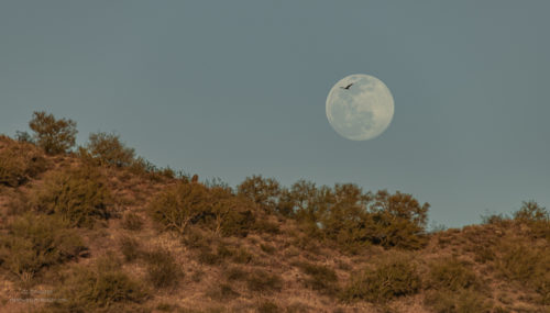
Figured I’d shoot moon rise the night before full moon and get by without the tripod.  When will I learn that hand-held just doesn’t do the trick.  Not saying I didn’t get a few decent shots, but they could have been better.  The next night there were clouds and I didn’t even bother.

first light Brushy Mountain full moon set Skull Valley Arizona

first light Brushy Mountain full moon set Skull Valley Arizona

first light Brushy Mountain full moon set Skull Valley ArizonaBut for the next morning I actually set the alarm and had the tripod ready.  The Photographers Ephemeris showed the moon setting on the top of Brushy Mountain and proved to be pretty close.  The timing was off because of the mountain’s elevation so the set happened about 40 minutes earlier than stated.  I jumped in and out of the RV in the chilly to me 43°.

pig Skull Valley Arizona

fall Cottonwood trees along dry wash Skull Valley Arizona

By afternoon the temperature reached mid 70s and I was motivated to go out for yet another walk.  Stopped by to feed the two nameless pigs my organic garbage then followed a bulldozed path across the mostly dry creek in search of colorful Cottonwood trees.

field fall Cottonwood trees Skull Valley Arizona

fall Cottonwood trees Skull Valley ArizonaDidn’t have far to go.  A long open field lined with Cottonwood trees that are slowly loosing green to gold.

yellow Fall Cottonwood trees boulders Skull Valley Arizona

yellow Fall Cottonwood tree boulders Skull Valley ArizonaI meandered a ways and returned by the same route as the walls of the creek are steeper than I wanted to negotiate.

windmill Skull Valley ArizonaThis three-hour walk I got in one mile.  Guess I’ll have to speed up a bit if I want more steps.  Naw, I like my saunters.

window view West grass trees Brushy Mountain clouds Skull Valley ArizonaDesk window view

I truly enjoy this time to just stay home and not meet anybody’s schedule but my own.  Yet many days I am lazy almost to the point of guilt.  I am thinking about how retirement fits into my personal sense of place.  The gears are clicking.

Sonoran Desert Kofa Mts last light clouds MST&T Rd BLM Kofa NWR ArizonaLate light on the Kofa Mts

I’d like to share the desert light.  Join me for a sense of place?

March 2022 Moon rise with Vulture near Wickenburg Arizona

2022 Geogypsy calendars are available to order at $25 each including shipping in the USA.  Leave a comment here or use the contact tab above.

Push my buttons!

  • Click to share on Facebook (Opens in new window) Facebook
  • Click to share on X (Opens in new window) X
  • Click to share on LinkedIn (Opens in new window) LinkedIn

Like this:

Like Loading...
Arizona, Places I've been, Skull Valley, United States connecting the dots, photography, retiremet, sense of place 35 Comments
25 June 2019

Found the Tropic Trail

A visitor at Bryce Canyon told me about hiking the Tropic Trail below the park’s main amphitheater and because I’m still connecting the dots to learn the geography of the surrounding landscape I decided to check it out.

Utah Prairie Dogs Mixing Circle Road Bryce Canyon National Park UtahTwo weeks ago on my second of two days off I headed out thinking I might stop at Fairyland Point and Mossy Cave on the way to the Tropic Trail.  I have to watch carefully for Utah Prairie Dogs every time I drive out the road from my RV as there is a fenced colony at the junction with SR63.  A horse trail crosses the main road and the critters come out to find feed, seed, and insects to eat making them vulnerable to vehicles.  On this day I saw pups with adults.

No space to park my big truckcamper at the small lot for Fairyland Point with only about 12 spaces all full.

brush valley view SR12 Utah

trees hoodoos from overlook SR12 UtahThe drive east on SR12 is spectacular so I have to stop and take in the view.  And there are hoodoos here too.

SR12 East UtahSometimes I can’t stop so take photos through the dirty windshield.  I call that street photography.

trees Mossy Cave parking SR12 East Bryce Canyon National Park UtahAnother full parking lot at Mossy Cave which is back in Bryce Canyon National Park, and a place I returned to in a couple days.

trees Bryce Canyon National Park cliffs UtahNo problem parking at the Tropic Trailhead with only three vehicles parked around the edges of a moderate-sized culdesac and room for several more.

Cicada oak tree Tropic Trl Bryce Canyon National Park wilderness UtahThe first thing I heard was a soft clicking I immediately recognized as Cicadas.  Yet they seemed so quiet compared to the almost deafening sound I’d heard in the Pacific Northwest, and the Midwest where I grew up.  Took a little searching but I found them munching away on the Gamble Oak leaves.  Wish I had recorded their sound.  Glad someone at Bryce did.


Tropic Trail Bryce Canyon National Park Wilderness UtahReally appreciated the three step turnstile over a fence to keep grazing animals out of the Bryce Canyon Wilderness Area.

trees cliffs Tropic Trail Bryce Canyon National Park Wilderness UtahA fine forest of Pinyon and Juniper plus Ponderosa Pine and Gamble Oak looking up at the walls of Bryce with intermittent shade and very little elevation gain.

trees cliff Tropic Trail Bryce Canyon National Park Wilderness Utah

yellow Primrose flower Tropic Trail Bryce Canyon National Park Wilderness UtahPrimrose

After the first ten minutes I had the trail to myself.

trees cliff Tropic Trail Bryce Canyon National Park Wilderness Utah

Sure is nice to find beautiful natural places that aren’t overcrowded.  I don’t want to sound jaded, but as a National Park Ranger I do see my fair share of crowds.

13b DSC_3129lecrw red Sky Rocket flowers & shadow Tropic Trl BRCA NP UT g-1-4

SkyrocketPainted Lady butterfly Tropic Trail Bryce Canyon National Park Wilderness UtahPainted Lady

trees cliffs Tropic Trail Bryce Canyon National Park Wilderness UtahI sauntered for 1 1/2 hours not making it the 2.8 miles up to Sunset or 3.6 miles to Sunrise points in Bryce Canyon National Park, or even to the base of the hoodoos.  I’m thinking that last elevation gain could be up to 1500 feet.

pine needle frame cliffs Tropic Trail Bryce Canyon National Park Wilderness UtahAfter a little research, I’m thinking the Tropic Trail is one of the routes used by 1890s Mormon settlers to run cattle to the top of the Paunsaugunt Plateau during summer.  Among the group of settlers, Ebenezer Bryce harvested timber in the lower canyons and is reported to have said, “It’s a hellofa a place to loose a cow.”  Though I question his use of “hell”.

old building pond hills Tropic UtahThere are some private residences along the gravel drive to the Tropic Trailhead and they sure do have some magnificent views.

side mirror view leaving Tropic Trail Tropic UtahI worked up an appetite and not many restaurant choices in Tropic but did enjoy a late lunch sitting outside and chatting with locals at the IDK Barbeque with good ribs.

trees hoodoos Mossy Cave Parking SR12 West Bryce Canyon National Park UtahThen for the pretty drive back up onto the Pausaungunt Plateau and still no parking at Mossy Cave.

hoodoos Queen's Garden trail from Rim Bryce Canyon National Park UtahJust as I pulled into the park an artist friend from the North Rim days sent a text.  They were at the lodge for lunch.  I met up with her crew of grown son and daughter with three kids. We all walked to the rim and Sunrise Point where they headed down the Queen’s Garden trail.

amphitheater valley Navajo Mountain Bryce Canyon National Park UtahI walked the rim trail south looking into the amphitheater below and trying once again to connect the dots.  I couldn’t actually see the Tropic Trail where I’d been strolling earlier under the trees.  Yet I did see the rocky outcrops and walls I’d been looking up at.  Do you see them?

When finding out of the way and unpeopled places I am hesitant to share their exact location.  Instead, I encourage you to make your own discoveries, or ask me privately.

Push my buttons!

  • Click to share on Facebook (Opens in new window) Facebook
  • Click to share on X (Opens in new window) X
  • Click to share on LinkedIn (Opens in new window) LinkedIn

Like this:

Like Loading...
Utah Bryce Canyon NP, connecting the dots 23 Comments

Hi, I’m Gaelyn, the Geogypsy

I retired after 29 summer seasons as a Park Ranger, traveling solo for 40+ years. My passions include travel, connecting to nature, photography, and sharing stories.

I started exploring US National Parks in 1977 and 20 years later became a seasonal Park Ranger.  I’ve lived full-time in a RV for 30 years working summers and playing winters.  I’m still trying to figure out what I want to be when I grow old, other than grow up.

Let’s share our stories.  Here’s more of mine…

My wheeleastate

I am currently…

…boondocking somewhere in southern Arizona.  In the area, give a shout.

Geogypsytraveler on YouTube

Follow my journey on YouTube. Just click the pic. Hope you’ll like, share, and subscribe.

Click image for 7 minute documentary (Password “geogypsy” lowercase)

Making the Gypsy documentary is a story of its own.  Click below for the rest of the story.

Living nomadically & connecting to nature documentary

Subscribe to Blog via Email

Enter your email address to subscribe to this blog and receive notifications of new posts by email.

Photos available for sale include prints, greeting cards, coffee mugs, tote bags, phone cases and more

Reflected Wave 24X16 metal print under $100

Custom Coffee Mugs

Many items to choose from including prints

The Last Blast 24 x 16″ metal print under $100

Need a signal boost? When I boondock on public lands sometimes signal is weak or intermittent and a booster helps. Click the pic to visit WeBoost.

Connecting to nature and the rest of the world too.

Please contact me for photo purchases not seen at GLOlmsted Photography

Order fulfillment is by Fine Art America. If you’re not happy with your purchase, for any reason, simply return it within 30 days, and you’ll receive a full refund of the purchase price.

Why read Geogypsy?

The gypsy life spring-summer 1998 - "You were a real pioneer. RV'ing before it was cool." ...Yogi

How do you process photos? - “Your photographs create an Emotional feeling in the viewer...that they become One with You.” …Cindy

Life’s transitions between travel and work play - "I know you love your job as much as you love travel -- it shines through all your posts." ...Sallie

Lions at Kruger National Park - “Wonderful post, thank you. I was hooked start to finish!” … Peter B

11 lessons looking back 2013 - “A great post -- made me think, made me smile, made me want to cry." ...Sallie

Wildlife video Kruger National Park - “Gorgeous, this makes me want to go straight to South Africa now.” … Ayngelina

Living nomadically & connecting to nature documentary - “What an experience you had and gave to the "crew." Sometimes I think you don't realize how unique and inspiring you are.” …Alan

Search

Popular Posts

1. Prioritize the well-being of nature over photography. 2. Educate yourself about the places you photograph. 3. Reflect on the possible impact of your actions. 4. Use discretion if sharing locations. 5. Know and follow rules and regulations. 6. Always follow Leave No Trace principles and strive to leave places better than you found them. 7. Actively promote and educate others about these principles

Categories

Archives

Sites I follow, read & recommend

  • A Full-time Life
  • A Yankee in Belgrade
  • Bob's Eyes
  • Box Canyon Blog
  • Camels and Chocolate
  • Dawns bloggy blog
  • In the Direction of Our Dreams
  • Jane in her infinite wisdom
  • Janie and Steve, Utah Trails
  • Kathie's Birds
  • Las Adventuras
  • Memorable Meanders
  • Oh, The Places They Go
  • On the Road Abode
  • Port Elizabeth Daily Photo
  • Stillhowlyntravels
  • Take to the Highway
  • Technomadia
  • the good luck Duck
  • Travel with the Bayfield Bunch
  • Wandering Earl
  • Wheeling It
  • Yogi's Den

Caught in a Slot 9×12 canvas print under $50

If you don’t like what’s going on in your government, contact your Congress

Directory of Senators

Directory of Representatives

Lijit

© Copyright 2008-2024. Geogypsytraveler.com
%d