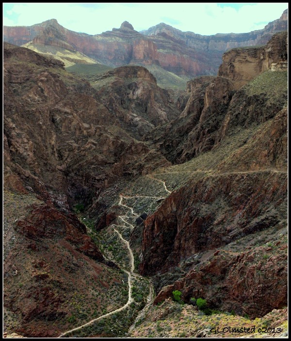
The Devil’s Corkscrew Bright Angel trail Grand Canyon National Park switchbacks across the Precambrian Vishnu schist. Long ago this trail cost a toll of money as well as body. Would you have paid to hike this?

Just frozen brains
It was hard to get out of our sleeping bags that morning at Indian Garden. Low 13 F! Both of us had ice on our stocking caps. Yet nature and coffee called.

Looking at the North Rim, Home Sweet Home
After breakfast we walked west towards Plateau Point overlook to warm up before heading up 3100 feet (945 m) for the final trek of 4.6 miles (7.4 km).

Yes, that’s Mike in front of that over weight pack
The trail starts up rather gradually across the Tonto Formation. Then Jacobs Ladder switchbacks across the widest band of exposed rock, the Redwall Limestone. Usually an impenetrable rock face, Bright Angel trail was built in an ancient fault zone that creates a break in this sheer cliff. (Note the offset on the light-colored wide layer almost at the top of the Coconino Sandstone.)

Mule train passing below resthouse
Three-mile Resthouse sits at the top of the Redwall, a dividing line between forest and desert-scrub habitats.

From here the trail travels more gradually over crumbly layers of shale mixed with limestone and sandstone. And, of course more switchbacks, with waterbars that are logs across the trail to keep it from washing away. Sort of like unevenly spaced steps with a rise of 6-18 inches (15-45 cm).

Next stop, Mile-and-a-Half Resthouse, which also offers compost toilets and during summer potable water and sits below yet another steep cliff face of Coconino Sandstone. Both resthouses provide a sheltered place to drop the every growing heavier packs and have a snack. (Eating would seem to lighten the load but didn’t feel that way.)

Plus couldn’t stop for long or the body would start to chill.

Seeing the second tunnel gave hope that we were almost at the top. Well after many more switchbacks and waterbars that is.

By the time we got to First tunnel I was too tired to lift my feet let alone the camera.

But once at the top with no heavy pack on my back I turned to see where we had been. I felt triumph and awe filled with wonder. Plus hunger so strong I was very cranky when Mike said to pick up my pack to catch the bus to where our truck was parked. That was quickly resolved with dinner at the Arizona Room of Bright Angel Lodge where we sat in quiet reflection and watched sunset over the canyon.

.jpg) Amy and Jan Indian Garden Camp
Amy and Jan Indian Garden CampI left camp first, but it wasn’t long before they passed me on this hike out of Grand Canyon. We had 4.6 miles (7.4 km) to hike with a gain of 3100 feet (945 meters).
.jpg) Morning light on canyon wall above camp
Morning light on canyon wall above campWe met again at 3-mile house.
.jpg) View south to Plateau Point from Bright Angel Trail
View south to Plateau Point from Bright Angel TrailThis trail has been used by people for hundreds of years. Native Americans first made the trail to access the spring fed Indian Garden where they farmed. In the late 1800s the trail was widened for tourists and Ralph Cameron charged $1 for its use. In the 1930s the National Park Service improved the trail.
.jpg) Three-mile house above Jacobs Ladder along Bright Angel Trail
Three-mile house above Jacobs Ladder along Bright Angel TrailWater and restrooms are provided here and at One-and-a-half mile house.
The steep cliffs of the Redwall Limestone present a major obstacle for trail building.
.jpg) South Rim at top of fault
South Rim at top of faultHowever the Bright Angel Fault makes a natural break. The rocks to the west (right) are uplifted 189 feet (58 meters) higher than those to the east.
+Bright+Angel+trail+GRCA+AZ+(800x600).jpg) Second tunnel (from the top)
Second tunnel (from the top)At this point I am standing at the top of the buff-colored Coconino Sandstone seen in the photo of the South Rim above.
.jpg) Pictographs
PictographsJust before the next tunnel and above the trail is a panel of pictographs.
From here I could tell I was almost to the top because the women coming down had on makeup and smelled like perfume.
.jpg) Gaelyn, Jan and Amy
Gaelyn, Jan and AmyAmy and Jan topped out of the canyon about one hour before I did. And I broke my own time out by almost half. Guess I’m in better shape after a summer season of hiking than for the spring hike during training after a lazy winter.
.jpg) Maggi’s house on South Rim
Maggi’s house on South RimRanger Maggi let us stay at her house that night and she drove us to Sophie’s Mexican Restaurant in Tusyan just south of the park where we bought her dinner.
.jpg) Jan and Amy with Prickly Pear Cactus Lemonade cocktail on El Tovar porch
Jan and Amy with Prickly Pear Cactus Lemonade cocktail on El Tovar porchIn the morning we did some South Rim sightseeing and bought a few souvenirs.
.jpg) Gaelyn with same
Gaelyn with sameThen we boarded the TransCanyon Shuttle at noon which returned us to the North Rim about 5pm.
In total we hiked 24 miles (38.62 km) over four days, a mile down and a mile up. It was awesome!
So would anyone like to join me next fall for a bloggers hike across Grand Canyon?

