• Home
  • About Geogypsy
    • Herstory
    • Parks where I’ve worked
  • Places I’ve been
    • United States
      • Arizona
        • Antelope Slot Canyon
        • Casa Grande Ruins National Monument
        • Colossal Cave Mountain Park
        • Flagstaff
        • Glen Canyon National Recreation Area
        • Grand Canyon National Park
          • Grand Canyon National Park North Rim
          • Grand Canyon National Park South Rim
          • Toroweap
        • Havasu Canyon
        • Horseshoe Bend
        • Jerome
        • Kaibab National Forest
        • Lee’s Ferry
        • Meteor Crater
        • Navajo Bridge
        • Oak Creek Canyon
        • Painted Desert
        • Pipe Springs National Monument
        • Prescott
        • Quartzsite
        • Saguaro National Park
        • Sedona
        • Sunset Crater Volcano National Monument
        • Vermilion Cliffs
        • Walnut Canyon National Monument
        • Wupatki National Monument
        • Yarnell
      • California
        • Anzaberrego
        • Bakersfield
        • Death Valley National Park
        • Joshua Tree National Park
        • Redwoods NP
        • Salton Sea
        • Yucca Valley
      • Colorado
        • Mesa Verde National Park
      • Florida
      • Illinois
        • IL River
        • Morton Arboretum
        • Starved Rock State Park
      • Michigan
      • Nevada
      • New Mexico
      • Oregon
        • Crater Lake NP
        • Mt Hood
        • Oregon Caves National Monument
      • Texas
        • Alpine Texas
        • Padre Island
        • Port Isabel
        • Rio Grande Valley
      • Utah
        • Brian’s Head
        • Bryce Canyon National Park
        • Buckskin Gulch
        • Cedar Breaks National Monument
        • Cedar City
        • Coral Pink Sand Dunes State Park
        • Dixie National Forest
        • Grand Staircase Escalante National Monument
        • Johnson Canyon
        • Kanab
    • World Travels
      • Germany
      • Mexico
      • South Africa
  • Tours
  • Photography
  • Work with Me
    • Sponsors
  • Contact
Geogypsy
Menu
  • Home
  • About Geogypsy
    • Herstory
    • Parks where I’ve worked
  • Places I’ve been
    • United States
      • Arizona
        • Antelope Slot Canyon
        • Casa Grande Ruins National Monument
        • Colossal Cave Mountain Park
        • Flagstaff
        • Glen Canyon National Recreation Area
        • Grand Canyon National Park
          • Grand Canyon National Park North Rim
          • Grand Canyon National Park South Rim
          • Toroweap
        • Havasu Canyon
        • Horseshoe Bend
        • Jerome
        • Kaibab National Forest
        • Lee’s Ferry
        • Meteor Crater
        • Navajo Bridge
        • Oak Creek Canyon
        • Painted Desert
        • Pipe Springs National Monument
        • Prescott
        • Quartzsite
        • Saguaro National Park
        • Sedona
        • Sunset Crater Volcano National Monument
        • Vermilion Cliffs
        • Walnut Canyon National Monument
        • Wupatki National Monument
        • Yarnell
      • California
        • Anzaberrego
        • Bakersfield
        • Death Valley National Park
        • Joshua Tree National Park
        • Redwoods NP
        • Salton Sea
        • Yucca Valley
      • Colorado
        • Mesa Verde National Park
      • Florida
      • Illinois
        • IL River
        • Morton Arboretum
        • Starved Rock State Park
      • Michigan
      • Nevada
      • New Mexico
      • Oregon
        • Crater Lake NP
        • Mt Hood
        • Oregon Caves National Monument
      • Texas
        • Alpine Texas
        • Padre Island
        • Port Isabel
        • Rio Grande Valley
      • Utah
        • Brian’s Head
        • Bryce Canyon National Park
        • Buckskin Gulch
        • Cedar Breaks National Monument
        • Cedar City
        • Coral Pink Sand Dunes State Park
        • Dixie National Forest
        • Grand Staircase Escalante National Monument
        • Johnson Canyon
        • Kanab
    • World Travels
      • Germany
      • Mexico
      • South Africa
  • Tours
  • Photography
  • Work with Me
    • Sponsors
  • Contact

Category: Kanab

29 May 2016

Earthfest Dancing with Dogs Parade Kanab Utah

May 14, 2016

01s DSCN6484clerw Forever Adventure Tours Earthfest parade Kanab UT g-3 (800x436)Who doesn’t love a parade?  The National Park Service at Grand Canyon was invited to march in the Earthfest Dancing with Dogs Parade in Kanab, Utah.  So seven Park Rangers from the North and South Rims walked in the number three position.  Couldn’t have been more than 12 positions in the parade.

It had been a very long time since I participated in a parade.  I marched as a Girl Scout more years ago than I want to remember.  When I lived in Tonasket, Washington I roller skated in a fall Mardi Gras parade.  Yea, wrong time of year but that’s the way we rolled.  And I also rode a horse in Tonasket’s Founder’s Day parade held during the rodeo.

03s DSCN6481clerw Earthfest parade staging Kanab UT g-3 (800x427)

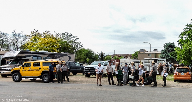
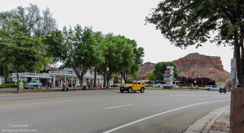
We left the North Rim Saturday at 6:30 am for the hour and a half drive to Kanab, Utah where it was already an hour later.  Confused?  Me all the time.  As are many visitors who come to the North Rim from Utah.  Six of us in the car, three from the South Rim.  One other Ranger met us in town at the Visitor Center staging area.

04s DSCN6539lerw Dyed Kingman turquoise & SS cuff & ring g-3 (800x600)

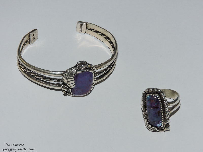
The Saturday Market had several booths set up selling jewelry and plants.  So you know where I headed.  In fact friends Dan and Cindy were selling and of course I saw something I liked, a cuff to match the ring I’d already bought from them.  The purplish color is a dyed Kingman turquoise which matches many of my favorite colored outfits.

05s DSCN6479clerw Greyhounds Earthfest Parade Kanab UT g-3 (620x800)

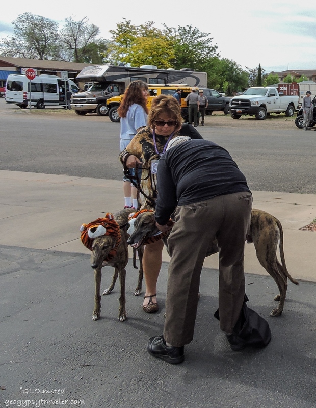
Many parade participants mingled in the parking lot including countless costumed Greyhounds, rescue dogs, many of whom matched their owners.  About 10:05 the Honor Guard lead us onto State Route 89 into downtown.  We followed the Forever Adventure Tours jeep.  There were BLM horse mounted Rangers, A Utah State DNR Ranger in an OHV, people dressed like trees, and did I mention LOTS of Greyhounds.

06s DSCN6493clerw NPS Earthfest parade Kanab UT g-3 (800x556)

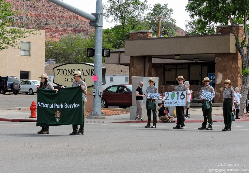
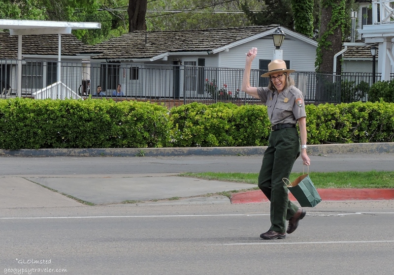
One of our Rangers was the Grand Marshall.  Two carried a NPS banner, which is really a green table cloth with NPS on it.  Two more carried small signs with “FindYourPark”, one in Spanish.  And we all carried green NPS paper bags filled with mixed candy and Condor stickers to give to the kids watching the parade.

07s DSCN6488clerw Gaelyn Earthfest parade Kanab UT g-3 (800x559)

There may have been more participants than onlookers along the four block route.  Yet in all fairness this was a first time event celebrating Earthfest, NPS 100th, and Greyhounds.  Interesting combination wouldn’t you say.  Yet it was a well received parade.  People clapped and cheered for the National Park Service.  We handed out candy and invited them to visit the North Rim.  Then turned around and walked back, minus the Honor Guard who dispersed at the turning point.

Afterwards the newly appointed tourism director took all us Rangers to brunch at Parry’s.  Then we made a quick stop for groceries which always needs to be done living so far from town.  And four of us headed back to the NR.

It’s possible Grand Canyon National Park will get more involved in future Kanab events.

All parade photos were taken by Bill who I asked to use my camera for this event.

Sorry I haven’t been visiting blogs lately but still having issues with a limited signal and time.  Looking into a stronger booster and open to suggestions.

Push my buttons!

  • Facebook
  • Twitter
  • LinkedIn

Like this:

Like Loading...
Kanab, Utah Earthfest, Greyhounds, parade, Park Rangers 20 Comments
06 April 2016

Dog friendly Bunting Trail in Kanab

April 3, 2016

Vermilion Cliffs Bunting Trail Kanab Utah

It’s so nice to live nearby the dog friendly Bunting Trail in Kanab, Utah with the first half mile an easy walk before ascending 800 feet (244 m) for the 1.25 miles (2 km) to the top.  Can’t say I’ve made it to the end yet.


Leg trap warning sign Bunting Trail Kanab UtahHowever we don’t go here for the two months some assholes set out traps presumably for coyotes.  Leave it to BLM with their almost anything goes attitudes.  And the trail is sloppy after rain or snow melt that creates a sandy, clay slick mess.

Sasha Bunting Trail Kanab Utah

With clear blue skies on Monday, Bill called because Sasha wanted to get out for some exercise.  Probably needed to check her social media along this frequently visited trail.

Vermilion Cliffs Bunting Trail Kanab Utah

Mostly we did a slow walk in the wash, not very far because my knee is still a little sore from my curb trip a few weeks ago.  Going up isn’t too bad, down still tough, and the sand made a soft surface to exercise leg muscles.  I paused frequently to stare at the towering Vermilion Cliffs.

Juniper tree root in wash Bunting Trail Kanab Utah

Besides where water cuts through the land it reveals so much story, layers of the rock and sand deposits and roots searching deep for water.  It was an absolutely gorgeous day in the high 60sF (15sC) with a light breeze.

Not much blooming but did see a lot of fresh growth at the tips of the Junipers.  Don’t know if it’s been too dry or the recent cold and light snow froze out the flowers.  Maybe it’s just too early for these spring blooms to show themselves.  The Tamarisk, or Salt Cedar, was leafing out, an invasive that sucks lots of water.

Kaibab Plateau from Bunting Trail head Kanab Utah

Didn’t make it to the dinosaur tracks this time.  But what the heck, the Bunting Trail is so close, we’re bound to be back.  Sasha will insist.  And some day I just might make it to the top where there is a small panel of petroglyphs and a bigger view.


BLM map Bunting Trail Kanab UtahDirections to trail head
From the stoplight at the junction of SR89 and SR89A the southern end of Kanab, Utah, go south toward Fredonia then turn right on Kanab Creek Drive.  About 2 miles (3 km) through the Ranchos Subdivision turn right on Stanfield Drive.  The trail head parking is at the bottom of a hill.  This tends to be a “locals” trail yet if you’re staying in Kanab with your pet try out the dog friendly Bunting Trail.

Push my buttons!

  • Facebook
  • Twitter
  • LinkedIn

Like this:

Like Loading...
Kanab, Utah Bunting Trail, dinosour tracks, hiking, petroglyphs 8 Comments
20 July 2015

Canyon scramble to search for rock art

Map showing canyon hiked Kanab UtahIt’s a small and beautiful side canyon off Angel Canyon where Kanab Creek flows.  There’s really not an established trail so required a canyon scramble to search for rock art.

Canyon hiked Kanab UtahBill parked on a two track off the highway and suggested we scramble down a sandy bank through dense vegetation, cross the creek and back up on the other side.  Not wanting to walk in sand with wet shoes that didn’t look real appealing to me so the other option was to walk across a bridge on the highway and trail blaze, which is what we did.  Actually we followed a semi-trail that could have been made by animals and used by people too.  We still had to cross a dry wash that feeds into the creek to get to the sandstone cliffs where the suspected rock art might be.  Looking across I thought I saw some possible scratching on a patina surface which turned out to be natural.

Canyon hiked Kanab UtahMany options for kind of trails down appeared and we finally chose one that looked the least steep then slid down the sand to the bottom about 80 feet and walked up the wash looking for the best place to get back up on the other side.  Bill was post-holing in the sand on the way up and I tried to follow his steps but his stride is longer than mine, yet I’m lighter and didn’t sink in as far.  Once on the bench we worked our way to the cliff face and began to look for rock art walking up canyon.

Toadstools in canyon Kanab UtahThe sandstone formations are so breathtaking it really didn’t matter if we found anything.

Shelter in canyon hiked Kanab UtahThere is a fire ring with log seats around it and then we saw this old structure which is accessed through a crack in the rock.  With a tin roof over timbers and a sweet little oil-can stove it looked pretty habitable to me.  Hard to say when the last time it was actually used but there was some rather modern trash around.

Indigenous, historic & contemporary rock art Kanab UtahWe continued ahead just a bit to the head of the canyon where we finally found the rock art, indigenous, historic and contemporary.  Once again, people add their story to the same area of rock, plus a few bullet holes.  Looked like sand deposits had buried some of the petroglyphs.

Sawed out rock in canyon hiked Kanab UtahThis sawed out piece of rock was a curiosity.  Wonder if someone cut out a petroglyph.

Circular spalled rock in canyon hiked Kanab UtahOf course the natural “rock art” is just as spectacular as the human if not more so.

Looking down canyon hiked Kanab UtahWe followed the cliff face back down the canyon admiring the views.  The truck was parked almost at the foot of the farthest bluff in the center of the above photo.

Princes Plume & Sacred Datura in canyon hiked Kanab UtahPrinces Plume was everywhere with some sacred datura thrown into the mix.

Looking up canyon hiked Kanab UtahWe went back down, crossed the wash and climbed back up again.  By now, both a little tired so had to stop a couple times along the way but we made it out to explore more the next day in Grand Staircase-Escalante National Monument.  But those stories are for another post.

Push my buttons!

  • Facebook
  • Twitter
  • LinkedIn

Like this:

Like Loading...
Kanab, Utah petroglyphs, rock art 21 Comments
← Older posts
Newer posts →

Hi, I’m Gaelyn, the Geogypsy

I retired after 29 summer seasons as a Park Ranger, traveling solo for 40+ years. My passions include travel, connecting to nature, photography, and sharing stories.

I started exploring US National Parks in 1977 and 20 years later became a seasonal Park Ranger.  I’ve lived full-time in a RV for 30 years working summers and playing winters.  I’m still trying to figure out what I want to be when I grow old, other than grow up.

Let’s share our stories.  Here’s more of mine…

My wheeleastate

I am currently…

…boondocking somewhere in southern Arizona.  In the area, give a shout.

Geogypsytraveler on YouTube

Follow my journey on YouTube. Just click the pic. Hope you’ll like, share, and subscribe.

Click image for 7 minute documentary (Password “geogypsy” lowercase)

Making the Gypsy documentary is a story of its own.  Click below for the rest of the story.

Living nomadically & connecting to nature documentary

Subscribe to Blog via Email

Enter your email address to subscribe to this blog and receive notifications of new posts by email.

Photos available for sale include prints, greeting cards, coffee mugs, tote bags, phone cases and more

Reflected Wave 24X16 metal print under $100

Custom Coffee Mugs

Many items to choose from including prints

The Last Blast 24 x 16″ metal print under $100

Need a signal boost? When I boondock on public lands sometimes signal is weak or intermittent and a booster helps. Click the pic to visit WeBoost.

Connecting to nature and the rest of the world too.

Please contact me for photo purchases not seen at GLOlmsted Photography

Order fulfillment is by Fine Art America. If you’re not happy with your purchase, for any reason, simply return it within 30 days, and you’ll receive a full refund of the purchase price.

Why read Geogypsy?

The gypsy life spring-summer 1998 - "You were a real pioneer. RV'ing before it was cool." ...Yogi

How do you process photos? - “Your photographs create an Emotional feeling in the viewer...that they become One with You.” …Cindy

Life’s transitions between travel and work play - "I know you love your job as much as you love travel -- it shines through all your posts." ...Sallie

Lions at Kruger National Park - “Wonderful post, thank you. I was hooked start to finish!” … Peter B

11 lessons looking back 2013 - “A great post -- made me think, made me smile, made me want to cry." ...Sallie

Wildlife video Kruger National Park - “Gorgeous, this makes me want to go straight to South Africa now.” … Ayngelina

Living nomadically & connecting to nature documentary - “What an experience you had and gave to the "crew." Sometimes I think you don't realize how unique and inspiring you are.” …Alan

Search

Popular Posts

1. Prioritize the well-being of nature over photography. 2. Educate yourself about the places you photograph. 3. Reflect on the possible impact of your actions. 4. Use discretion if sharing locations. 5. Know and follow rules and regulations. 6. Always follow Leave No Trace principles and strive to leave places better than you found them. 7. Actively promote and educate others about these principles

Categories

Archives

Sites I follow, read & recommend

  • A Full-time Life
  • A Yankee in Belgrade
  • Bob's Eyes
  • Box Canyon Blog
  • Camels and Chocolate
  • Dawns bloggy blog
  • In the Direction of Our Dreams
  • Jane in her infinite wisdom
  • Janie and Steve, Utah Trails
  • Kathie's Birds
  • Las Adventuras
  • Memorable Meanders
  • Oh, The Places They Go
  • On the Road Abode
  • Port Elizabeth Daily Photo
  • Stillhowlyntravels
  • Take to the Highway
  • Technomadia
  • the good luck Duck
  • Travel with the Bayfield Bunch
  • Wandering Earl
  • Wheeling It
  • Yogi's Den

Caught in a Slot 9×12 canvas print under $50

If you don’t like what’s going on in your government, contact your Congress

Directory of Senators

Directory of Representatives

Lijit

© Copyright 2008-2024. Geogypsytraveler.com
%d