• Home
  • About Geogypsy
    • Herstory
    • Parks where I’ve worked
  • Places I’ve been
    • United States
      • Arizona
        • Antelope Slot Canyon
        • Casa Grande Ruins National Monument
        • Colossal Cave Mountain Park
        • Flagstaff
        • Glen Canyon National Recreation Area
        • Grand Canyon National Park
          • Grand Canyon National Park North Rim
          • Grand Canyon National Park South Rim
          • Toroweap
        • Havasu Canyon
        • Horseshoe Bend
        • Jerome
        • Kaibab National Forest
        • Lee’s Ferry
        • Meteor Crater
        • Navajo Bridge
        • Oak Creek Canyon
        • Painted Desert
        • Pipe Springs National Monument
        • Prescott
        • Quartzsite
        • Saguaro National Park
        • Sedona
        • Sunset Crater Volcano National Monument
        • Vermilion Cliffs
        • Walnut Canyon National Monument
        • Wupatki National Monument
        • Yarnell
      • California
        • Anzaberrego
        • Bakersfield
        • Death Valley National Park
        • Joshua Tree National Park
        • Redwoods NP
        • Salton Sea
        • Yucca Valley
      • Colorado
        • Mesa Verde National Park
      • Florida
      • Illinois
        • IL River
        • Morton Arboretum
        • Starved Rock State Park
      • Michigan
      • Nevada
      • New Mexico
      • Oregon
        • Crater Lake NP
        • Mt Hood
        • Oregon Caves National Monument
      • Texas
        • Alpine Texas
        • Padre Island
        • Port Isabel
        • Rio Grande Valley
      • Utah
        • Brian’s Head
        • Bryce Canyon National Park
        • Buckskin Gulch
        • Cedar Breaks National Monument
        • Cedar City
        • Coral Pink Sand Dunes State Park
        • Dixie National Forest
        • Grand Staircase Escalante National Monument
        • Johnson Canyon
        • Kanab
    • World Travels
      • Germany
      • Mexico
      • South Africa
  • Tours
  • Photography
  • Work with Me
    • Sponsors
  • Contact
Geogypsy
Menu
  • Home
  • About Geogypsy
    • Herstory
    • Parks where I’ve worked
  • Places I’ve been
    • United States
      • Arizona
        • Antelope Slot Canyon
        • Casa Grande Ruins National Monument
        • Colossal Cave Mountain Park
        • Flagstaff
        • Glen Canyon National Recreation Area
        • Grand Canyon National Park
          • Grand Canyon National Park North Rim
          • Grand Canyon National Park South Rim
          • Toroweap
        • Havasu Canyon
        • Horseshoe Bend
        • Jerome
        • Kaibab National Forest
        • Lee’s Ferry
        • Meteor Crater
        • Navajo Bridge
        • Oak Creek Canyon
        • Painted Desert
        • Pipe Springs National Monument
        • Prescott
        • Quartzsite
        • Saguaro National Park
        • Sedona
        • Sunset Crater Volcano National Monument
        • Vermilion Cliffs
        • Walnut Canyon National Monument
        • Wupatki National Monument
        • Yarnell
      • California
        • Anzaberrego
        • Bakersfield
        • Death Valley National Park
        • Joshua Tree National Park
        • Redwoods NP
        • Salton Sea
        • Yucca Valley
      • Colorado
        • Mesa Verde National Park
      • Florida
      • Illinois
        • IL River
        • Morton Arboretum
        • Starved Rock State Park
      • Michigan
      • Nevada
      • New Mexico
      • Oregon
        • Crater Lake NP
        • Mt Hood
        • Oregon Caves National Monument
      • Texas
        • Alpine Texas
        • Padre Island
        • Port Isabel
        • Rio Grande Valley
      • Utah
        • Brian’s Head
        • Bryce Canyon National Park
        • Buckskin Gulch
        • Cedar Breaks National Monument
        • Cedar City
        • Coral Pink Sand Dunes State Park
        • Dixie National Forest
        • Grand Staircase Escalante National Monument
        • Johnson Canyon
        • Kanab
    • World Travels
      • Germany
      • Mexico
      • South Africa
  • Tours
  • Photography
  • Work with Me
    • Sponsors
  • Contact

Category: United States

28 June 2023

On the road for summer

Yes, I am far behind blogging, and also posting videos. It’s already a busy summer.  In fact I’m trying to catch them up to at least the same amount of time behind.  I last posted about the amazing pillars of rocks in Chiricahua National Monument visited in April, and that video can be found here.

late light boulders Indian Bread Rocks RA BLM Bowie AZIndian Bread Rocks Recreation Area

The next place I stayed at for two weeks, so lots of photos coming with that story.

trees rainbow storm clouds Skull Valley AZYes, I went home for several weeks to regroup, make plans, and not be on the road for Memorial Day weekend.  Maybe I’m crazy to travel during summer.

First of June I left for summer travels.  First I visited several friends and don’t have much to share from those stops, but do have many wonderful memories.

grass SF Pks rain clouds FR545 Wupatki NM AZSan Francisco Peaks from Wupatki National Monument

I returned to a few familiar places with different views.

Wotons Throne & Cape Royal Desert View SR GRCA NP AZWotons Throne from South Rim

view S Cape Royal NR GRCA NP AZWotons Throne from North Rim

Then I went to the South and North rims of Grand Canyon and that story and pics will be coming, eventually.

view S JP cliffs mt clouds SR320 Pioche NVBLM camp view near Pioche Nevada

Finally got to Utah and visited several more friends before starting to feel the heat of summer and heading into Nevada to several new to me places.

old log cabin Dutch John Well US93 NVDutch John Well

And I’m enthralled with Nevada landscapes.

view N red Paintbrush flowers scrub trees Egan Range sunset clouds White Pine County Rd 3 NVAs a friend said MOAN, for the Middle of ABSOLUTELY Nowhere, along America’s Loneliest Highway.  It’s gorgeous!  And the high elevation keeps me summer cool.

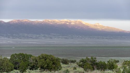
Jakey Valley and Egan Range

And now I find myself waiting for another holiday weekend to pass, avoiding possible rain, and staying in temperatures below 90°.

Kanab UTPainted on a street in Kanab Utah

Where next?  Stay tuned, and I will catch up eventually.  I might even make it to Oregon this summer.

Push my buttons!

  • Click to share on Facebook (Opens in new window) Facebook
  • Click to share on X (Opens in new window) X
  • Click to share on LinkedIn (Opens in new window) LinkedIn

Like this:

Like Loading...
Arizona, Nevada, Places I've been, RV life, United States, Utah boondocking, friendocking, RV living, summer 17 Comments
15 June 2023

Wonderful spires of rock at Chiricahua National Monument

hoodoos view W Massai Pt Chiricahua NM AZChiricahua National Monument was established in 1924 by President Calvin Coolidge and 84% of this 12,025 acre monument is designated as wilderness.  In 1934 the Civilian Conservation Corps (CCC) began improving the road and building trails and structures.  Yet millions of years before a volcanic eruption began the geologic process that would ultimately create the spires, pillars, and hoodoos currently protected in Chiricahua National Monument.

old cars Lowell Dist Bisbee AZIt was almost the end of April when I left Bisbee and continued exploring southeastern Arizona.  Next stop Chiricahua National Monument.

Sulphur Springs Valley SR181 N AZ

Sulphur Springs Valley SR181 N AZThe drive to the foot of the Chiricahua Mountains crossing Sulphur Springs Valley was mostly agricultural land.

border patrol check pt SR181 N AZAnd because the area is within 30 miles of the border with Mexico there’s a check point which simply entails a quick stop and carry on.

Chiricahua NM mapOnce I entered Chiricahua National Monument there was a small cemetery for Erickson family members who settled here in 1888 building the Faraway Ranch, but their home was closed for renovations.  They were preceded by the Chiricahua Apaches as the first known people to occupy the area—and visited by the Spanish during the 1500s—before being relocated by the government in 1886.

Bonita Canyon Dr CHIR NM AZ

Bonita Canyon Dr CHIR NM AZI stopped at the visitor center and picked up my Junior Ranger book before taking the Bonita Canyon Drive eight miles up to its end at Massai Point, an 1170 foot climb on narrow road with a length restriction of 24 feet.  Mine is about 21 feet total.

hoodoos view W Massai Pt Chiricahua NM AZ

hoodoos Massai Pt Chiricahua NM AZThe views took my breath away.  The west view beyond a basin filled with rock spires or hoodoos, across the Sulphur Valley and to the Dragoon Mountains about 70 miles away, where I just came from.

hoodoos Massai Pt CHIR NM AZI could barely take it all in and the afternoon was waning plus I still had to find a nearby camp so I could return in the morning and walk at least a little of the 17 miles of trails.

Pinery Canyon Rd Chiricahua NF AZ

Pinery Canyon Rd Chiricahua NF AZI use several different apps to look for free dispersed/boondock camping sites and headed for the recommended Pinery Canyon Road in the adjacent Chiricahua National Forest.  Rough road took me 30 minutes to drive five miles before I found a primitive campground under the trees with absolutely no signal.

lizard Massai trl Chiricahua NM AZ

hoodoos Massai trl Chiricahua NM AZWaking to 40° inside the camper prompted me to leave early and return to Chiricahua’s Massai Point to walk a trail and get a closer look at this rock.

view N hoodoos lookout Massai trl Chiricahua NM AZ

view SW hoodoos Massai Pt CHIR NM AZRoughly 27 million years ago a cataclysmic volcanic eruption spewed ash and molten debris at super-sonic speeds and formed the approximately 12 mile wide Turkey Creek Caldera located just to the south of the monument.  Ash and debris settled and compacted, forming a thick layer of rock called rhyolite tuff. This rock layer has fissured and eroded over time, forming the spectacular rock pillars of Chiricahua National Monument.

stone overlook Massai Pt CHIR NM AZ

viewer hoodoos Massai Pt CHIR NM AZThe Massai nature trail features a unique stone built overlook with multiple-point viewer across almost 180°.

trees hoodoos Massai trl Chiricahua NM AZ

view W rock trees Massai trl Chiricahua NM AZThe trail is an easy walk over boulders and under trees with many interesting shapes along the way.

trees hoodoos trl Massai Pt CHIR NM AZ

Mexican Jay bird Chiricahua NM AZOf course at my rate of pace, the .5 mile nature trail took over an hour while taking photos and videos.

twisted Juniper tree bark Massai trl Chiricahua NM AZBeing I’m more of a saunterer than hiker I didn’t take on any of the other longer trails.  Plus I needed a new camp for the night.

Chiricahua hat pinChiricahua Jr Ranger badge

Gaelyn swearing in Jr Ranger badge CHIR NM AZI did return to the visitor center for my hat pin, sticker, and Junior Ranger badge.

boulders sunset clouds Indian Bread Rocks BLM Bowie AZThen I exited Chiricahua National Monument and drove north to Wilcox, Arizona where I filled a propane tank before heading to my next destination, the new to me, Indian Bread Rocks Recreation Area.  A whole different kind of geology, and that story will be coming next.

You can visit the national monument’s official website here https://www.nps.gov/chir/index.htm

Push my buttons!

  • Click to share on Facebook (Opens in new window) Facebook
  • Click to share on X (Opens in new window) X
  • Click to share on LinkedIn (Opens in new window) LinkedIn

Like this:

Like Loading...
Arizona, Chiricahua National Monument, National Parks and Monuments, Places I've been, United States geology, history, national monument, travel 14 Comments
06 June 2023

Busy in Bisbee Arizona

mural Bisbee AZTowards the end of April, catching up with a friend in Bisbee kept me busy with quite a bit of chatting, eating out, and a tour of the Copper Queen Mine.  Many will know the streets of Bisbee can be steep and narrow but I lucked out and camped in front of my friends house at very little slant.

sign Coronado NM AZAfter the second day visiting Tumacácori National Historic Park I continued east towards Bisbee with a Walmart night in Sierra Vista along the way.  The next day, not far down the road, I saw a brown sign for Coronado National Memorial and the visitor center was only five paved miles off SR92.  So why not, I had a little time.  Unfortunately, not really enough time to explore scenic roads or trails.

Spanish mail & helmet Coronado NM Sierra Vista AZThis site commemorates the Coronado expedition and cultural conflict and exchange between indigenous peoples and Spaniards during the 1500s.  I perused the visitor center displays and was overwhelmed by the weight of the chain-mail soldiers had to wear.

Coronado NM hat pinPicked up my Junior Ranger book, but no badge because I wasn’t there long enough.  However I did buy a hat pin and sticker.

old cars Lowell Dist Bisbee AZ

classic cars Lowell Dist Bisbee AZ

old car at pump Lowell Dist Bisbee AZ

classic car Lowell Dist Bisbee AZ

Strayhound bus Lowell Dist Bisbee AZOnce I got to Bisbee and parked on a few leveling boards we went to lunch at the Bisbee Breakfast Club and walked around one of the many historic districts admiring the classic cars, trucks, and even a converted Greyhound bus.

Copper Queen Mine tour bldg Bisbee AZSaturday morning we went to a local Farmers’ Market with lots of good produce and hand-crafted products to look at.  In the afternoon we took a tour of the Copper Queen Mine in Bisbee.

going in Copper Queen Mine tour bldg Bisbee AZWe road a mine car on tracks 1500 feet into the mountain and got off it a couple times for short walks and talks. Tough place to take photos and only took the phone.

toilet cart Copper Queen Mine tour bldg Bisbee AZGuess what that is

Our guide was a retired miner, very informative, and lots of stories.  Tour was a little over an hour.

Copper Queen Mine hat pinThen to the gift shop where I got another hatpin and sticker.

old bldg Bisbee AZWe had dinner downtown at Bisbee Table after finally finding parking and a 45-minute wait for seating that was entirely worth it just to eat the truffle fries.  The walk around town while waiting proved entertaining as it was Alice in Bisbeeland night and many people were dressed up for the occasion.  If I’d known, would have worn my madhatter hat.

Sierra & Boots standoff Bisbee AZSunday we stayed home and talked away the day then enjoyed dinner at the neighbors.  Bisbee has a great vibe and seems full of interesting people.

peekaboo bunny humping Bisbee AZMural can be covered for the easily offended

Back to work after the weekend and I finished a video driving historic US80 between Tacna and Yuma, Arizona, also known as the Mother of Arizona Highways.  Plus I posted the blog post about my hot Easter weekend in the Sonoran Desert.  Yes, I am far behind from real time.

Said a sad goodbye Wednesday morning and bought a few groceries before heading east and northeast across Springs Valley towards the Chiricahua Mountains and my next destination.

______________________________________________________

Still planning summer road trip northward.  Who lives in southwestern Utah, southern or western Nevada, or northeastern California?  Tentative route: Utah SR18 N, SR56 W; Nevada SR319 W, SR93 S, SR375 W, US6 W; California US395 N. Short side trips considered.

Push my buttons!

  • Click to share on Facebook (Opens in new window) Facebook
  • Click to share on X (Opens in new window) X
  • Click to share on LinkedIn (Opens in new window) LinkedIn

Like this:

Like Loading...
Arizona, Bisbee, Places I've been, United States Copper Queen Mine tour, historic 21 Comments
← Older posts
Newer posts →

Hi, I’m Gaelyn, the Geogypsy

I retired after 29 summer seasons as a Park Ranger, traveling solo for 40+ years. My passions include travel, connecting to nature, photography, and sharing stories.

I started exploring US National Parks in 1977 and 20 years later became a seasonal Park Ranger.  I’ve lived full-time in a RV for 30 years working summers and playing winters.  I’m still trying to figure out what I want to be when I grow old, other than grow up.

Let’s share our stories.  Here’s more of mine…

My wheeleastate

I am currently…

…boondocking somewhere in southern Arizona.  In the area, give a shout.

Geogypsytraveler on YouTube

Follow my journey on YouTube. Just click the pic. Hope you’ll like, share, and subscribe.

Click image for 7 minute documentary (Password “geogypsy” lowercase)

Making the Gypsy documentary is a story of its own.  Click below for the rest of the story.

Living nomadically & connecting to nature documentary

Subscribe to Blog via Email

Enter your email address to subscribe to this blog and receive notifications of new posts by email.

Photos available for sale include prints, greeting cards, coffee mugs, tote bags, phone cases and more

Reflected Wave 24X16 metal print under $100

Custom Coffee Mugs

Many items to choose from including prints

The Last Blast 24 x 16″ metal print under $100

Need a signal boost? When I boondock on public lands sometimes signal is weak or intermittent and a booster helps. Click the pic to visit WeBoost.

Connecting to nature and the rest of the world too.

Please contact me for photo purchases not seen at GLOlmsted Photography

Order fulfillment is by Fine Art America. If you’re not happy with your purchase, for any reason, simply return it within 30 days, and you’ll receive a full refund of the purchase price.

Why read Geogypsy?

The gypsy life spring-summer 1998 - "You were a real pioneer. RV'ing before it was cool." ...Yogi

How do you process photos? - “Your photographs create an Emotional feeling in the viewer...that they become One with You.” …Cindy

Life’s transitions between travel and work play - "I know you love your job as much as you love travel -- it shines through all your posts." ...Sallie

Lions at Kruger National Park - “Wonderful post, thank you. I was hooked start to finish!” … Peter B

11 lessons looking back 2013 - “A great post -- made me think, made me smile, made me want to cry." ...Sallie

Wildlife video Kruger National Park - “Gorgeous, this makes me want to go straight to South Africa now.” … Ayngelina

Living nomadically & connecting to nature documentary - “What an experience you had and gave to the "crew." Sometimes I think you don't realize how unique and inspiring you are.” …Alan

Search

Popular Posts

1. Prioritize the well-being of nature over photography. 2. Educate yourself about the places you photograph. 3. Reflect on the possible impact of your actions. 4. Use discretion if sharing locations. 5. Know and follow rules and regulations. 6. Always follow Leave No Trace principles and strive to leave places better than you found them. 7. Actively promote and educate others about these principles

Categories

Archives

Sites I follow, read & recommend

  • A Full-time Life
  • A Yankee in Belgrade
  • Bob's Eyes
  • Box Canyon Blog
  • Camels and Chocolate
  • Dawns bloggy blog
  • In the Direction of Our Dreams
  • Jane in her infinite wisdom
  • Janie and Steve, Utah Trails
  • Kathie's Birds
  • Las Adventuras
  • Memorable Meanders
  • Oh, The Places They Go
  • On the Road Abode
  • Port Elizabeth Daily Photo
  • Stillhowlyntravels
  • Take to the Highway
  • Technomadia
  • the good luck Duck
  • Travel with the Bayfield Bunch
  • Wandering Earl
  • Wheeling It
  • Yogi's Den

Caught in a Slot 9×12 canvas print under $50

If you don’t like what’s going on in your government, contact your Congress

Directory of Senators

Directory of Representatives

Lijit

© Copyright 2008-2024. Geogypsytraveler.com
%d