• Home
  • About Geogypsy
    • Herstory
    • Parks where I’ve worked
  • Places I’ve been
    • United States
      • Arizona
        • Antelope Slot Canyon
        • Casa Grande Ruins National Monument
        • Colossal Cave Mountain Park
        • Flagstaff
        • Glen Canyon National Recreation Area
        • Grand Canyon National Park
          • Grand Canyon National Park North Rim
          • Grand Canyon National Park South Rim
          • Toroweap
        • Havasu Canyon
        • Horseshoe Bend
        • Jerome
        • Kaibab National Forest
        • Lee’s Ferry
        • Meteor Crater
        • Navajo Bridge
        • Oak Creek Canyon
        • Painted Desert
        • Pipe Springs National Monument
        • Prescott
        • Quartzsite
        • Saguaro National Park
        • Sedona
        • Sunset Crater Volcano National Monument
        • Vermilion Cliffs
        • Walnut Canyon National Monument
        • Wupatki National Monument
        • Yarnell
      • California
        • Anzaberrego
        • Bakersfield
        • Death Valley National Park
        • Joshua Tree National Park
        • Redwoods NP
        • Salton Sea
        • Yucca Valley
      • Colorado
        • Mesa Verde National Park
      • Florida
      • Illinois
        • IL River
        • Morton Arboretum
        • Starved Rock State Park
      • Michigan
      • Nevada
      • New Mexico
      • Oregon
        • Crater Lake NP
        • Mt Hood
        • Oregon Caves National Monument
      • Texas
        • Alpine Texas
        • Padre Island
        • Port Isabel
        • Rio Grande Valley
      • Utah
        • Brian’s Head
        • Bryce Canyon National Park
        • Buckskin Gulch
        • Cedar Breaks National Monument
        • Cedar City
        • Coral Pink Sand Dunes State Park
        • Dixie National Forest
        • Grand Staircase Escalante National Monument
        • Johnson Canyon
        • Kanab
    • World Travels
      • Germany
      • Mexico
      • South Africa
  • Tours
  • Photography
  • Work with Me
    • Sponsors
  • Contact
Geogypsy
Menu
  • Home
  • About Geogypsy
    • Herstory
    • Parks where I’ve worked
  • Places I’ve been
    • United States
      • Arizona
        • Antelope Slot Canyon
        • Casa Grande Ruins National Monument
        • Colossal Cave Mountain Park
        • Flagstaff
        • Glen Canyon National Recreation Area
        • Grand Canyon National Park
          • Grand Canyon National Park North Rim
          • Grand Canyon National Park South Rim
          • Toroweap
        • Havasu Canyon
        • Horseshoe Bend
        • Jerome
        • Kaibab National Forest
        • Lee’s Ferry
        • Meteor Crater
        • Navajo Bridge
        • Oak Creek Canyon
        • Painted Desert
        • Pipe Springs National Monument
        • Prescott
        • Quartzsite
        • Saguaro National Park
        • Sedona
        • Sunset Crater Volcano National Monument
        • Vermilion Cliffs
        • Walnut Canyon National Monument
        • Wupatki National Monument
        • Yarnell
      • California
        • Anzaberrego
        • Bakersfield
        • Death Valley National Park
        • Joshua Tree National Park
        • Redwoods NP
        • Salton Sea
        • Yucca Valley
      • Colorado
        • Mesa Verde National Park
      • Florida
      • Illinois
        • IL River
        • Morton Arboretum
        • Starved Rock State Park
      • Michigan
      • Nevada
      • New Mexico
      • Oregon
        • Crater Lake NP
        • Mt Hood
        • Oregon Caves National Monument
      • Texas
        • Alpine Texas
        • Padre Island
        • Port Isabel
        • Rio Grande Valley
      • Utah
        • Brian’s Head
        • Bryce Canyon National Park
        • Buckskin Gulch
        • Cedar Breaks National Monument
        • Cedar City
        • Coral Pink Sand Dunes State Park
        • Dixie National Forest
        • Grand Staircase Escalante National Monument
        • Johnson Canyon
        • Kanab
    • World Travels
      • Germany
      • Mexico
      • South Africa
  • Tours
  • Photography
  • Work with Me
    • Sponsors
  • Contact

Category: Joshua Tree National Park

15 March 2015

Exploring Hidden Valley and more in Joshua Tree

First light on boulders thru window Jumbo Rock Campground Joshua Tree National Park CaliforniaJust after 6am, the rising sun turns the rock a peachy pink and I want to go out and take photos but it’s cold with a bitter wind so I’ll settle with the view through my window.  Yet later in the day boulders surrounding Hidden Valley block the wind making it possible to explore more of Joshua Tree National Park.

Hall of Horrors Joshua Tree National Park California

Boulders Hall of Horrors Joshua Tree National Park CaliforniaThe third day of my visit I’m headed to the town of Joshua Tree via many stops along the way in the park.  Once again I am impressed with all the paved pull-offs to hike from or just enjoy the views.  Although some of the names are rather chilling like the Hall of Horrors where magnificent boulder piles beckon, especially climbers who are many here.  But the wind blows cold so my stop is brief.

Saddle Rock Joshua Tree National Park CaliforniaSaddle Rock across the road is also a popular climbing route.  In my younger years this would have appealed to me but now I contend myself to easier boulder hopping and just sitting on the sun warmed rock absorbing the earths energy.

Looking towards Hidden Valley Joshua Tree National Park CaliforniaBy the time I get to Hidden Valley trailhead the sun is up high and it’s feeling warmer so I take off one layer yet bring it along on the hike.  I think wearing all these layers to stay warm adds 10 pounds and an extra size.  The large parking lot is 90% full and some little cars have pulled into the larger RV spaces.  I don’t understand why people do that when there’s empty parking for cars.

I chatted with a lady, Lyn, I’d seen taking photos with her tripod set up close to a bush.  She was trying for a Phainopepla hiding in the branches.  Give her credit for hauling the tripod around as she was told to do by a photographic instructor.  Guess I’m too lazy.

Wall of boulders Hidden Valley Joshua Tree National Park California

Entering Hidden Valley Joshua Tree National Park CaliforniaTowering walls of imposing boulders seem to make the other side inaccessible.  Yet story has it that in 1936, only months before Joshua Tree National Monument was established by President Franklin Roosevelt, long time rancher Bill Keys blasted the opening that is used today to access excellent untouched pasture land.

Hidden Valley Joshua Tree National Park CaliforniaSure glad the landscape is protected now, yet I still appreciate slipping into this boulder protected valley to explore out of the wind.

Balanced boulders Hidden Valley Joshua Tree National Park CaliforniaI took the loop trail counter clockwise, unlike most everyone else.  Seemed I’d have the sun to my back more of the walk this way which makes it easier to take photos under the high noon sun.  Not the best time for photography but definitely the better time for warmth.  I find it really hard to pick out just a few photos because everything was fascinating, the shape of the rock, piling of boulders, plants, and the crazy climbers.

Climbers Hidden Valley Joshua Tree National Park California

Rock climber Hidden Valley Joshua Tree National Park CaliforniaJoshua Tree has become a world-class rock climbing location yet problems have arisen.  People create their own trails trampling on vegetation, and nesting birds and archeological sites can be disturbed.  Climber groups are working with the park to reduce this impact.

Hidden Valley Joshua Tree National Park CaliforniaHidden Valley is like a miniature world, a micro-climate of it’s own.

Sun behind boulders Hidden Valley Joshua Tree National Park CaliforniaEven at high noon boulders provide much needed shade which during summer temperatures of at least 100F (38C) could mean the difference between life and death.

Hidden Valley Joshua Tree National Park CaliforniaThe smallest of holes and crevices collect and hold moisture that supports many plant and animal species.

Dwarf Grumpy rock Hidden Valley Joshua Tree National Park CaliforniaThe valley is a transition zone with pines, junipers and oaks living amongst the boulders while Joshua Trees and cactus occupy the desert valley floor.  Food abounds here for wildlife like acorns which the Mountain Quail and chipmunks feast on in the fall.  And the Pinyon Jay who helps perpetuate the Pinyon Pine by carrying seeds off miles away where it may be forgotten and germinate.  The junipers are considered ‘relics’ surviving from a less arid climate of the past now confined to higher elevations and areas such as Hidden Valley.

Pinyon pine Hidden Valley Joshua Tree National Park CaliforniaNative human desert dwellers from the past also harvested acorns and pine nuts, the later being a most important food source.  After knocking the green cones off branches they placed the cones in fire causing them to open and expose the seeds while roasting them in the process.  Plus pine pitch made a good glue for waterproofing baskets and repairing clay pots.

Hidden Valley Joshua Tree National Park California

Hidden Valley Joshua Tree National Park CaliforniaEven the twisted and contorted skeletal shapes of the dead trees, and their shadow, add to the intricacy of this diverse landscape.

Hidden Valley Joshua Tree National Park CaliforniaAnd don’t ask me why, but the combination of boulders and Joshua Trees remind me of Cartoon Town.

Visitor with Lambchop Hidden Valley Joshua Tree National Park CaliforniaI was very surprised to see this lady carry Lambchop and just had to take a picture.  She told me to check out instagram and sure enough it’s all over the place.  I didn’t realize there’s a Lambchop following but guess it’s like ‘a collector for everything’.  Does anybody remember Sherry Lewis with Lambchop?

Dog head rock Hidden Valley Joshua Tree National Park California

Hidden Valley Joshua Tree National Park CaliforniaThe about one mile (1.6km) loop trail took lollygag me two hours.  It’s mostly an easy level walk with only a few places to climb step-like boulders.

Entrance station & Joshua Tree California

Showers sign Coyote Corner Joshua Tree CaliforniaFrom Hidden Valley I headed to the town of Joshua Tree for lunch, shower at Coyote Corner, and internet.

Benchmark CR-2 1976 Jumbo Rocks Campground Joshua Tree National Park CaliforniaThen drove the 23 miles (37km) back to Jumbo Rocks campground and went for a late afternoon boulder hop along a similar path as before but this time discovering yet another benchmark which seem to draw me in like a magnet.

Shadows on rock Jumbo Rocks Campground Joshua Tree National Park CaliforniaThen as the shadows grew long temperatures quickly dropped 10-15 degrees and I happily ended the day in my warm camper only venturing out once more for a not so great, hand held shot of the almost full moon.

Moon Jumbo Rocks Campground Joshua Tree National Park California
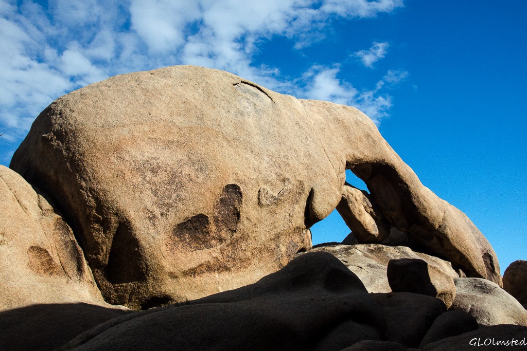
For the pareidolias out there, what shapes do you see in the rocks?  I saw Grumpy—one of the 7 dwarves—and a dog wearing a baseball hat backwards, heads only for both.

Push my buttons!

  • Facebook
  • Twitter
  • LinkedIn

Like this:

Like Loading...
California, Joshua Tree National Park, National Parks and Monuments Hidden Valley 25 Comments
10 March 2015

In and out of Joshua Tree with stops along the way

Boulders White Tank campground Joshua Tree National Park CaliforniaWoke up Tuesday at White Tank campground in Joshua Tree National Park and knew I had to make a plan.  I wanted to see as much of the accessible park as possible and leave by Friday to avoid the weekend crowd.  Also needed a few supplies from town and wanted to stop at the Oasis Visitor Center where headquarters are located and try to locate some ex-Grand Canyon Rangers.  Plus I could take advantage of an internet signal in town.  So headed to 29 Palms with the intention of returning to the park to stay at Jumbo Rocks campground for three nights as it is centrally located.

Motorhome Belle campground Joshua Tree National Park CaliforniaI first stopped at Belle camp just down the road.  It does have a few more larger sites but is still a small campground with only 18 sites.  National Park campgrounds were built when RVs weren’t as popular or large so with tent camping in mind the sites are typically not very accommodating for big units.  However, if creative and during mid-week it looks possible to get a pretty good sized unit squeezed between the rocks.

Landscape Joshua Tree National Park CaliforniaWhere the boulder piles are not the landscape is dense and diverse.  Creosote bushes seem to be everywhere with cholla cactus mixed in.  But it’s the Joshua Trees, icon of the Mojave Desert, that stand the tallest with arms outstretched, thus the name given by early Mormon settlers.

 Joshua Tree bloom Joshua Tree National Park CaliforniaAnd some beginning to bud.

Entrance station, 29 Palms & Bullion Mts Joshua Tree National Park CaliforniaSoon I dropped into the Colorado Desert and the valley below, out the gate and into civilization.

Roadrunner at propane place Joshua Tree California29 Palms is a military town I’m not overly impressed with.  But I was able to get groceries, fuel up and be entertained by this begging roadrunner at the propane stop.  The owner, also very entertaining, actually stopped in the middle of hooking up the propane tank to feed it and told me he’d watched many generations of this family.  I didn’t bother with the “do not feed wildlife” lecture and took advantage of the photo opp.

Returned to the park via a stop at the Oasis Visitor Center which is currently closed for renovations.  That could be happening at many parks in preparation for the Park Service Centennial in 2016.   A small trailer is being used for sales and information plus a covered tent outside where a Ranger and volunteer were helping people plan their visit.  Also wanted to reserve for the Keys Ranch tour but they are booked for two weeks.  Have done it before but would have happily done it again.  Keep this in mind if visiting.

Live Oak day use area Joshua Tree National Park CaliforniaLive Oak Day Use Area

Once back in the park I appreciated the many paved pull offs and picnic areas to just park and hike, wander into the desert, or clamber on the boulders.  I only stopped at a few this day but tried to hit as many as possible over my visit.

Live Oak boulder view Joshua Tree National Park California

Boulder balance Live Oak view Joshua Tree National Park CaliforniaPlus I was headed to Jumbo Rocks campground and would have a couple more days to explore.  Already at 2:30 the 125 site campground was getting full.  There are very few sites that are large and the some of the bigger RVs are literally parked rock to rock.  $10/night or less with Park Pass, pit toilets, no water and an amphitheater for weekend campfire programs.

Darth Vader rock Jumbo Rocks campground Joshua Tree National Park CaliforniaI chose a parallel parking spot at #121 on the first loop on the left.  Provided nice views of the boulders and the Darth Vader rock, as I saw it, that towered over my site.

Gaelyn's shadow against boulders Jumbo Rocks campground Joshua Tree National Park CaliforniaAfter getting settled it was time for a boulder-hop walk.

Elephant rock Jumbo Rocks campground Joshua Tree National Park CaliforniaEverywhere I looked there were incredible shapes to be seen.  On the above Darth Vader rock, when looked at from a different angle, what in the above image would be on the left, an elephant appeared.  Now you know I love elephants, but I was in California.  I must be a pareidolia.  Are you?

P-rock Jumbo Rocks campground Joshua Tree National Park California

Jumbo Rocks campground Joshua Tree National Park CaliforniaIt’s difficult to capture the sculptural vastness of the boulders put together like an awkward puzzle.  Stacked precariously and ready to roll.  But who can say when.  I’m reminded of trying to capture the essence of Grand Canyon in a single view but my mind was truly on overload.

Raven on boulders Jumbo Rocks campground Joshua Tree National Park CaliforniaRaven on boulders

These rock piles began underground eons ago as molten magma called monzogranite.  As it cooled and crystallized, cracks formed horizontally and vertically. Chemical weathering caused by groundwater eroded the granite blocks widening cracks and rounding edges eventually eroding the surface soil and leaving these piles exposed.

 Jumbo Rocks campground Joshua Tree National Park California

Person on boulders Jumbo Rocks campground Joshua Tree National Park CaliforniaPerson on boulders

Pretty easy to get around without strenuous climbing, unless that’s what you desire.  The erosion created low angled steps in some places with a natural gritty texture.

 Jumbo Rocks campground Joshua Tree National Park CaliforniaI frequently took the easier way winding around boulders through washes where I saw more plants growing in the broken granitic soil.  Wandered in a circle keeping the campground to my right so no fear of getting lost.  But I could see how easily one could get lost out in these boulders, by choice or not.

Desert Rock-pea Jumbo Rocks campground Joshua Tree National Park CaliforniaNot much is blooming quite yet at 4400 feet (1341 m) with nights in the 30s other than the hardy Desert Rock-pea that will bloom in even the driest years.

Lizard Jumbo Rocks campground Joshua Tree National Park CaliforniaThe desert seems to demand slowing down to really see the complex diversity of life.  Yet because I’m not out walking at dawn, dusk or night I miss seeing most of the animals that live here.

White-crowned Sparrow Jumbo Rocks campground Joshua Tree National Park CaliforniaI heard bird song and rustling in dry bushes so paused trying to find them.  The White-crowned sparrow is not new to me but I’m amazed to see it in this thorny bush.

Squirrel on boulder with nest below Jumbo Rocks campground Joshua Tree National Park CaliforniaA squirrel on lookout not far from its shelter.

Last light on boulders Jumbo Rocks campground Joshua Tree National Park CaliforniaSunset without clouds wasn’t very exciting, but the last glow on the boulders warmed me like the chill temperatures could not.

Jumbo Rocks campground Joshua Tree National Park CaliforniaOf course I took hundreds of photos but there’s more to come as I continued to explore Joshua Tree National Park.


Push my buttons!

  • Facebook
  • Twitter
  • LinkedIn

Like this:

Like Loading...
California, Joshua Tree National Park Jumbo Rocks campground 32 Comments
08 March 2015

Exploring the lower desert of Joshua Tree

Two deserts meet in Joshua Tree National Park, the lower Colorado below 3000 feet and higher elevation Mojave.  My first day in the park, entering from the western entrance at Cottonwood, I spent exploring the lower desert of Joshua Tree.

Cottonwood & Eagle Mountains Cottonwood Springs Road Joshua Tree National Park CaliforniaAfter avoiding the weekend crowd, and the rain, I left my free BLM campsite just outside the west entrance of the park driving over the 2800 foot Cottonwood Pass sandwiched between the Cottonwood and Eagle Mountains.

First stop, the Cottonwood campground to take advantage of their RV dump station.  Although not a fun chore it’s a fact of life living on the road in a RV with holding tanks.  Fill the fresh water tank and dump the black and gray.  I can usually go three weeks, conservatively, and was on week two but planned to be in the park almost a week.  I did get a bit of a cold shower when the water came out like a fire hose.  It’s a double dump station with easy access and no extra charge over park entrance fees and I have a Park Pass for that.  Even if you’re not in a RV this will be the last place for water until the eastern park entrances in 29 Palms at 38 miles (61 km) or Joshua Tree at 56 (90 km).  So fill up those containers.

Mistletoe in Creosote bush Joshua Tree National Park CaliforniaChores done, I stopped into the Visitor Center to ask about the mistletoe growing mostly on the scrub oaks.  The bright red berries really stand out and I know mistletoe is a parasite so I wanted to know if it was native to this desert landscape.  The Ranger informed me it’s considered a “semi-parasite” because it does absorb nutrients from its host plant but is also capable of photosynthesis so doesn’t typically kill the host unless there is too much growing on the tree or the tree is environmentally stressed due to extended drought.  Many birds and small mammals eat the mistletoe berries then poop and spread them around.  It is not considered a problem in the park.

RV Cottonwood Springs campground Joshua Tree National Park CaliforniaBeing happy with that answer, I felt ready to continue into the park across the Colorado Desert landscape headed for White Tank campground, which at 3800 feet (1158 m) is in the other desert, the high Mojave.  I could have hiked the 7.2 mile (11.6 km) round trip trail to Lost Palms Oasis starting just beyond the Cottonwood Springs campground but having recently explored palm canyons at Anza-Borrego chose not to.  However I did drive through the campground which is of the old National Park design clearly set up with tent camping in mind.  The parking for sites is small with only a few parallel to the road for larger RVs maybe up to 30 feet.  It be tight.  No hookups, pit toilets, and endless desert to explore but I’d stick with the free BLM camping outside the park.

Cottonwood Springs Road Joshua Tree National Park CaliforniaContinuing on Cottonwood Springs Road which meanders across Smoke Tree Wash I was glad for the many paved pull offs because the shoulder looks soft.  Not a safe place to be during a flash flood.  I stopped many times to admire the spidery ocotillo, green-barked palo verde, smoke trees, patches of cholla cactus and the dominant creosote.  Not much in bloom yet but the recent rains will bring that on soon.  No Joshua trees yet as they grow at a higher elevation.

Cottonwood Springs Road Joshua Tree National Park CaliforniaThe Colorado desert is hot and dry, dry ground and dry air.  Non-desert dwellers often miss the beauty found in these adaptive plants and animals living under a relentless sun, little water and summer temperatures over 100F (38C).  I appreciate these survival skills even if I don’t want to be here in summer.  Seeds can lie dormant for several years until conditions are favorable.  The kangaroo rat, amongst others, obtains water from the food it eats.  Most animals travel during the cool of night and I did not see them.

Turkey Flats Pinto Basin Road Joshua Tree National Park California

Ocotillo Patch Pinto Basin Road Joshua Tree National Park CaliforniaThe paved road turns northwest into Pinto Basin at a junction with Old Dale and Black Eagle Mine Roads which lead to mines outside the park and require 4×4.  I headed across Turkey Flats, presumably named because of an unsuccessful try at poultry farming, and stopped at the Ocotillo Patch.  Being the leaves of the ocotillo are rain dependent they can grow and drop as often as five times a year and the recent moisture had a few of them blooming with fire red tips.

Cholla cactus garden Pinto Basin Road Joshua Tree National Park CaliforniaNext stop, the Cholla Cactus Garden, not a place to sit for a picnic, but the 1/4 mile nature walk guided me safely through a wonderland as the cactus spines glowed under an afternoon break in the clouds.  You really don’t want to touch or even get near these “jumping” cholla as their spines easily embed in your skin and clothing but aren’t easily removed and can be quite painful.

Storm clouds Pinto Basin Road Joshua Tree National Park CaliforniaLeaving the, slightly, warmer Colorado Desert through a transition zone into the Pinto Mountains and Mojave Desert the temperature dropped as the altitude rose and the last remnants of a storm passed over as I pulled into White Tank campground.

Rainbow White Tank campground Joshua Tree National Park CaliforniaI actually enjoyed the soft rain which is a gift to the desert and received a rainbow gift in return.

Arch Rock White Tank campground Joshua Tree National Park California

Sunshine returned and I walked no more than 1/10th of a mile from my campsite to Arch Rock.  I looked for a way to get behind the arch for sunset but it would have required some serious bouldering which I didn’t want to do returning after dark.

Tow truck & stuck trailer White Tank campground Joshua Tree National Park CaliforniaI backed into the last of 15 campsites off the turn around at the end of the loop in White Tank.  None of the parking sites are big with some barely large enough for a small car.  No water, pit toilets, $10/night or less with park passes.  A sign at the camp entrance states nothing over a total length of 25 feet, and personally I think that would be pushing it.  In fact just before dark, a man and his wife pulling a too long trailer hung it on the turn around and he had to disconnect and get a tow truck to get out.  Poor guy, I’d have been freakin’ and frozen.  Night temps got down to the high 30s.

Moon over boulders White Tank campground Joshua Tree National Park CaliforniaThe opportunities to climb and hop from boulder to boulder are many around White Tank and I went out in the morning for a little exploration.  And there were Joshua Trees!  I was in the Mojave Desert now.

Boulders White Tank campground Joshua Tree National Park California

Push my buttons!

  • Facebook
  • Twitter
  • LinkedIn

Like this:

Like Loading...
California, Joshua Tree National Park Colorado desert 20 Comments
← Older posts
Newer posts →

Hi, I’m Gaelyn, the Geogypsy

I retired after 29 summer seasons as a Park Ranger, traveling solo for 40+ years. My passions include travel, connecting to nature, photography, and sharing stories.

I started exploring US National Parks in 1977 and 20 years later became a seasonal Park Ranger.  I’ve lived full-time in a RV for 30 years working summers and playing winters.  I’m still trying to figure out what I want to be when I grow old, other than grow up.

Let’s share our stories.  Here’s more of mine…

My wheeleastate

I am currently…

…boondocking somewhere in southern Arizona.  In the area, give a shout.

Geogypsytraveler on YouTube

Follow my journey on YouTube. Just click the pic. Hope you’ll like, share, and subscribe.

Click image for 7 minute documentary (Password “geogypsy” lowercase)

Making the Gypsy documentary is a story of its own.  Click below for the rest of the story.

Living nomadically & connecting to nature documentary

Subscribe to Blog via Email

Enter your email address to subscribe to this blog and receive notifications of new posts by email.

Photos available for sale include prints, greeting cards, coffee mugs, tote bags, phone cases and more

Reflected Wave 24X16 metal print under $100

Custom Coffee Mugs

Many items to choose from including prints

The Last Blast 24 x 16″ metal print under $100

Need a signal boost? When I boondock on public lands sometimes signal is weak or intermittent and a booster helps. Click the pic to visit WeBoost.

Connecting to nature and the rest of the world too.

Please contact me for photo purchases not seen at GLOlmsted Photography

Order fulfillment is by Fine Art America. If you’re not happy with your purchase, for any reason, simply return it within 30 days, and you’ll receive a full refund of the purchase price.

Why read Geogypsy?

The gypsy life spring-summer 1998 - "You were a real pioneer. RV'ing before it was cool." ...Yogi

How do you process photos? - “Your photographs create an Emotional feeling in the viewer...that they become One with You.” …Cindy

Life’s transitions between travel and work play - "I know you love your job as much as you love travel -- it shines through all your posts." ...Sallie

Lions at Kruger National Park - “Wonderful post, thank you. I was hooked start to finish!” … Peter B

11 lessons looking back 2013 - “A great post -- made me think, made me smile, made me want to cry." ...Sallie

Wildlife video Kruger National Park - “Gorgeous, this makes me want to go straight to South Africa now.” … Ayngelina

Living nomadically & connecting to nature documentary - “What an experience you had and gave to the "crew." Sometimes I think you don't realize how unique and inspiring you are.” …Alan

Search

Popular Posts

1. Prioritize the well-being of nature over photography. 2. Educate yourself about the places you photograph. 3. Reflect on the possible impact of your actions. 4. Use discretion if sharing locations. 5. Know and follow rules and regulations. 6. Always follow Leave No Trace principles and strive to leave places better than you found them. 7. Actively promote and educate others about these principles

Categories

Archives

Sites I follow, read & recommend

  • A Full-time Life
  • A Yankee in Belgrade
  • Bob's Eyes
  • Box Canyon Blog
  • Camels and Chocolate
  • Dawns bloggy blog
  • In the Direction of Our Dreams
  • Jane in her infinite wisdom
  • Janie and Steve, Utah Trails
  • Kathie's Birds
  • Las Adventuras
  • Memorable Meanders
  • Oh, The Places They Go
  • On the Road Abode
  • Port Elizabeth Daily Photo
  • Stillhowlyntravels
  • Take to the Highway
  • Technomadia
  • the good luck Duck
  • Travel with the Bayfield Bunch
  • Wandering Earl
  • Wheeling It
  • Yogi's Den

Caught in a Slot 9×12 canvas print under $50

If you don’t like what’s going on in your government, contact your Congress

Directory of Senators

Directory of Representatives

Lijit

© Copyright 2008-2024. Geogypsytraveler.com
%d