
July 1-12, 2017
Not sure where the time goes in July at Grand Canyon. Mostly work with a little bit of play thrown in and suddenly it’s almost the end of the month and my season is half over. I’ve been remiss in posting so this is a catch up and photo heavy which hopefully tells the story of what’s happened in July so far at Grand Canyon.
 When roving out the trail to Cape Royal sometimes it’s the smaller scenes deep in the canyon that catch my eye.
 No way I could ignore the heady aroma of the blooming Cliff rose. How I wish to share the almost overwhelming sweet smell. Here mixed with the brilliant firecracker penstemon so appropriate to the July holiday.

 But of course we don’t shoot fireworks at Grand Canyon. Instead the North Rim holds a wonderfully wet 4th of July water parade. This year featuring not only Uncle Sam ready to soak everyone within reach but five Kaibab squirrely Rangers, and a mule.
 Captured a few sunsets—because Rangers get paid in sunsets you know—while anxiously awaiting monsoon storms.
 Yet the clouds have been mostly teasing with very little rain as they skirt around to the east as seen from Point Imperial overlook.
 Humphrey Peak from SR89 S to Flagstaff
Took a trip to Flagstaff over a three day weekend to grocery shop. Yea, four hours away there is real stores with fresh organic fruit and vegetables. Also went to dinner with a friend to my current favorite Greek Taverna.
 Then camped overnight in the Coconino National Forest off US180 on the way to the South Rim for a Grand Canyon centennial meeting the next day. The park will celebrate 100 years in 2019.

 After the meeting at Headquarters I walked to the Rim Trail and watched the storm approach with only a few rain drops.


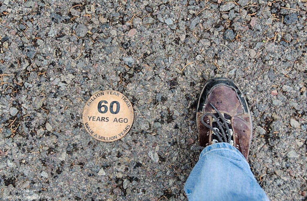 This is also known as the Trail of Time which from where I joined it takes you backwards in time to Verkamp’s Visitor Center or forward in time to the Yavapai Point Geology Museum where I headed. One long step equals one million years with examples of the rock layers along the way.
Camped that night in a friend and fellow Ranger’s driveway. I may have discovered the secret of visiting the South Rim during the business of summer by getting on the road shortly after sunrise. I was actually able to park my big rig at the overlooks on the way east on SR64.
 Last Chance Mine location light spot just below center
 Grandview is famous for rim access to the Last Chance Mine 3,000 feet below on Horseshoe Mesa where Pete Berry staked a copper mining claim in 1890. The Grandview trail now used by hikers served miners for about 20 years. In 1897, Berry built the Grandview Hotel for adventuresome tourists.
 Yet Grandview Point also offers views to familiar Zoroaster, Brahma, and Deva temples seen from the North Rim. I could even see the lodge just below the horizon almost dead center.

 Next stop Moran Point, named after artist Thomas Moran who accompanied John Wesley Powell in 1873 on a geologic survey of Grand Canyon. His paintings prompted Congress to establish western national parks.


 Surprisingly I had Lippan Point overlook all to my self for about three minutes. The views are far and deep. Following where the Colorado River carved westward into the oldest basement rock in Grand Canyon at 1.8 billion years. Plus Hance Rapid can be seen 3.8 miles away, considered one of Grand Canyon’s most hazardous rapids as the Colorado River falls the height of a three-story building.


 This was my first time stopping to the east of the national park at the Navajo Tribal Park which straddles the canyon of the Little Colorado River including the confluence with the Colorado River. I donated a few dollars to park and look around. Actually more like looking down as a gorge is described as deeper than it is wide. Water only flows during spring snowmelt and summer monsoon season. In addition, rows of tables display Navajo arts and crafts for sale.
 I looked at the wares yet knew there would be more at Cameron Trading Post operating since 1915 where I stopped for lunch. I usually have their Navajo Taco on fry bread but figured the Green chili stew would be easier to take home for leftovers but then I ate it all instead. I glanced at the pawn jewelry and nothing jumped out at me so I saved money but then I did buy a jar of prickly pear syrup for making the most amazing margaritas ever.
 As I drove north on SR89 through the painted desert clouds raced across the sky with rays of sunshine lighting up Echo Cliffs and intermittent rain fell.
 Approaching Marble canyon and Navajo bridge feels like I’m almost home even though there’s still a two hour drive ahead.


And I had to stop at Navajo Bridge in hopes to see condors. I hung out, looked downstream and up, under the bridges and along the cliff faces but no condors on this stop.
 Continued home toward threatening skies, more intermittent rain, and sunshine so kept craning my neck for a rainbow with no luck.
 Also had to stop at the overlook to see where I’ve been. No wonder it takes me so long to get anywhere with all the stopping along the way. It is about the journey yet I do have a destination when in the work season mode.
 Which takes me up onto the Kaibab Plateau and forest with meadows full of flowers which I vowed to return to, and did.